|
|
|
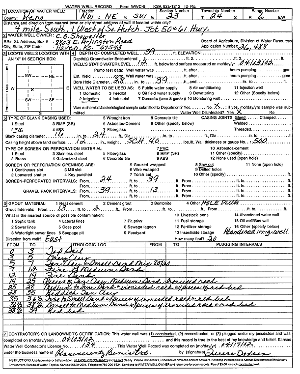
Specific Water Well Detail |
|
|
| Location Info | |||
| Owner: Showalter, C. B. | Status: Constructed | ||
| Location: T24S, R6W, Sec. 23, NW NE SW | County: Reno | ||
| Directions: from Jct 50 and 61 Hwy: 4 mi S, 1 mi W, South Hutchinson | |||
| Latitude: 37.9469828 | Longitude: -97.9527538 | Datum NAD 27 | |
| Latitude: 37.9469949 | Longitude: -97.953085 | Datum NAD 83 | |
| Longitude and latitude calculated by Survey from township-range-section-quarter calls. Only good to within the quarter call accuracy. | |||
| View well on interactive map | |||
| General Info | ||
| Well Depth: 39 ft. | Elevation: ft. | |
| Static Water Level: 12 ft. | Est. Yield: gpm. | |
| Comp. Date: 03-Apr-2002 | Well Use: Irrigation | |
| DWR Applic. #: 26488 | Other ID: | |
| Links | |
| View info from Wizard Water Level Data base... | |
| View info from WIMAS Water Right Data base... | |
| Driller Info | ||
| Driller: Rosencrantz-Bemis Enterprises, Inc. | License #: 134 | |
| Scanned Form | View scan |
|
Chemical Sample Submitted?: No
Water Well disinfected?: Yes | ||
| Bore hole diameter: 28 inches to 39 ft | ||
| Casing Info | ||
| Casing Type: PVC
Casing Joints: Glued |
Diam: 16 in. to 24 ft | |
| Casing height above land surface: 12 in
Casing Weight: 40 lbs/ft Wall thickness or gauge no.: .500 | ||
| Screen and Perforation Info | ||
| Screen Type: PVC | Screen Openings: Saw cut | |
| Screen-perforated intervals | From: 24 ft to 39 ft | |
| Gravel pack intervals | From: 39 ft to 13 ft | |
| Grout Info | ||
| Grout used: | From: 13 to 2 ft | |
| Source of Possible Contamination | ||
| Source: Abandoned irrig. well | ||
| Direction from well: East | Distance: 20 ft | |
| Lithologic Log
(Log data entered by KGS.) | ||
| From: 0 ft. to 3 ft. | top soil | |
| From: 3 ft. to 5 ft. | gray clay | |
| From: 5 ft. to 7 ft. | tan clay and small sand mix (80/20) | |
| From: 7 ft. to 12 ft. | fine to medium sand | |
| From: 12 ft. to 19 ft. | fine sand | |
| From: 19 ft. to 25 ft. | Pieces of tan clay, medium sand, ironated rock | |
| From: 25 ft. to 28 ft. | medium to fine sand and ironated rock with pieces of red bed | |
| From: 28 ft. to 35 ft. | reddish tan clay | |
| From: 35 ft. to 36.6 ft. | fine to small sand with pieces of ironated rock and red bed | |
| From: 36.6 ft. to 38.5 ft. | small to medium sand with pieces of ironated rock and red bed | |
| From: 38.5 ft. to 39 ft. | red bed | |