|
|
|
Specific Water Well Detail |
|
|
| Location Info | |||
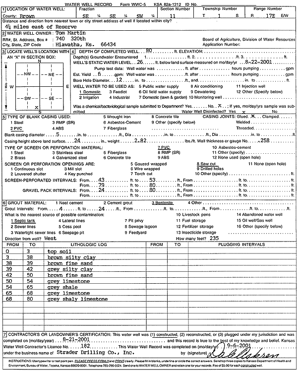
| Owner: Martin, Tom | Status: Constructed | ||
| Location: T1S, R17E, Sec. 11, SE SE SW | County: Brown | ||
| Directions: from Reserve: 4.25 mi E | |||
| Latitude: 39.9728298 | Longitude: -95.4812403 | Datum NAD 27 | |
| Latitude: 39.9728327 | Longitude: -95.4815002 | Datum NAD 83 | |
| Longitude and latitude calculated by Survey from township-range-section-quarter calls. Only good to within the quarter call accuracy. | |||
| View well on interactive map | |||
| General Info | ||
| Well Depth: 80 ft. | Elevation: ft. | |
| Static Water Level: 26 ft. | Est. Yield: 6 gpm. | |
| Comp. Date: 21-Aug-2001 | Well Use: Domestic | |
| DWR Applic. #: | Other ID: | |
| Driller Info | ||
| Driller: Strader Drilling Co., Inc. | License #: 182 | |
| Scanned Form | View scan |
|
Chemical Sample Submitted?:
Water Well disinfected?: | ||
| Casing Info | ||
| Casing Type:
Casing Joints: |
Diam: in. to ft | |
| Casing height above land surface: in
Casing Weight: lbs/ft Wall thickness or gauge no.: | ||
| Screen and Perforation Info | ||
| Screen Type: | Screen Openings: | |
| Screen-perforated intervals | From: ft to ft | |
| Gravel pack intervals | From: ft to ft | |
| Grout Info | ||
| Grout used: | From: to ft | |
| Source of Possible Contamination | ||
| Source: | ||
| Direction from well: | Distance: ft | |
| Lithologic Log
(Log data entered by KGS.) | ||
| From: 0 ft. to 3 ft. | Topsoil | |
| From: 3 ft. to 38 ft. | Brown silty clay | |
| From: 38 ft. to 39 ft. | Brown fine sand | |
| From: 39 ft. to 42 ft. | Gray silty clay | |
| From: 42 ft. to 50 ft. | Brown fine sand | |
| From: 50 ft. to 54 ft. | Gray limestone | |
| From: 54 ft. to 65 ft. | Gray shale | |
| From: 65 ft. to 68 ft. | Gray limestone | |
| From: 68 ft. to 80 ft. | Gray shaley limestone | |