|
|
|
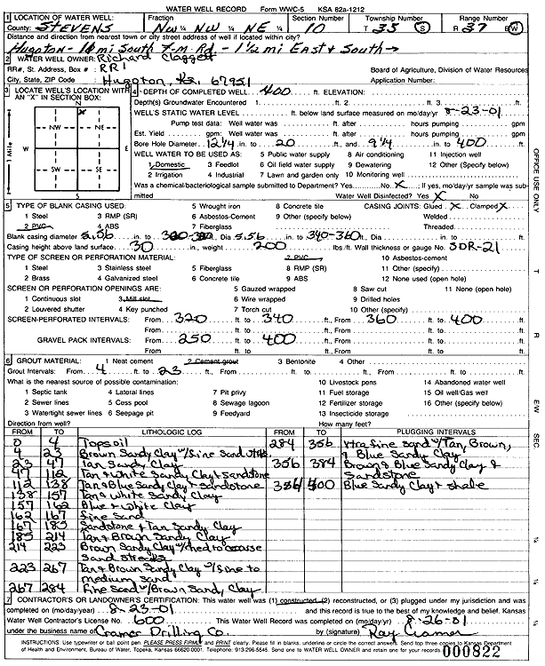
Specific Water Well Detail |
|
|
| Location Info | |||
| Owner: Claggett, Richard | Status: Constructed | ||
| Location: T35S, R37W, Sec. 10, NW NW NE | County: Stevens | ||
| Directions: from Hugoton: 11 mi S on F-m Rd, 1.25 mi E, S into site | |||
| Latitude: 37.0240223 | Longitude: -101.3278006 | Datum NAD 27 | |
| Latitude: 37.0240487 | Longitude: -101.3282396 | Datum NAD 83 | |
| Longitude and latitude calculated by Survey from township-range-section-quarter calls. Only good to within the quarter call accuracy. | |||
| View well on interactive map | |||
| General Info | ||
| Well Depth: 400 ft. | Elevation: ft. | |
| Static Water Level: ft. | Est. Yield: gpm. | |
| Comp. Date: 23-Aug-2001 | Well Use: Domestic | |
| DWR Applic. #: | Other ID: | |
| Driller Info | ||
| Driller: Ray Cramer Drilling Co. | License #: 600 | |
| Scanned Form | View scan |
|
Chemical Sample Submitted?:
Water Well disinfected?: | ||
| Casing Info | ||
| Casing Type:
Casing Joints: |
Diam: in. to ft | |
| Casing height above land surface: in
Casing Weight: lbs/ft Wall thickness or gauge no.: | ||
| Screen and Perforation Info | ||
| Screen Type: | Screen Openings: | |
| Screen-perforated intervals | From: ft to ft | |
| Gravel pack intervals | From: ft to ft | |
| Grout Info | ||
| Grout used: | From: to ft | |
| Source of Possible Contamination | ||
| Source: | ||
| Direction from well: | Distance: ft | |
| Lithologic Log
(Log data entered by KGS.) | ||
| From: 0 ft. to 4 ft. | topsoil | |
| From: 4 ft. to 23 ft. | brown sandy clay with fine sand streaks | |
| From: 23 ft. to 47 ft. | tan sandy clay | |
| From: 47 ft. to 112 ft. | tan and white sandy clay and sandstone | |
| From: 112 ft. to 138 ft. | tan and blue sandy clay and sandstone | |
| From: 138 ft. to 157 ft. | tan and white sandy clay | |
| From: 157 ft. to 162 ft. | blue and white clay | |
| From: 162 ft. to 167 ft. | fine sand | |
| From: 167 ft. to 185 ft. | sandstone and tan sandy clay | |
| From: 185 ft. to 214 ft. | tan and brown sandy clay | |
| From: 214 ft. to 223 ft. | brown sandy clay with med to coarse sand streaks | |
| From: 223 ft. to 267 ft. | tan and brown sandy clay with fine to medium sand | |
| From: 267 ft. to 284 ft. | fine sand with brown sandy clay | |
| From: 284 ft. to 356 ft. | extra fine sand with tan, brown, and blue sandy clay | |
| From: 356 ft. to 384 ft. | brown and blue sandy clay and sandstone | |
| From: 384 ft. to 400 ft. | blue sandy clay and shale | |