|
|
|
Specific Water Well Detail |
|
|
| Location Info | |||
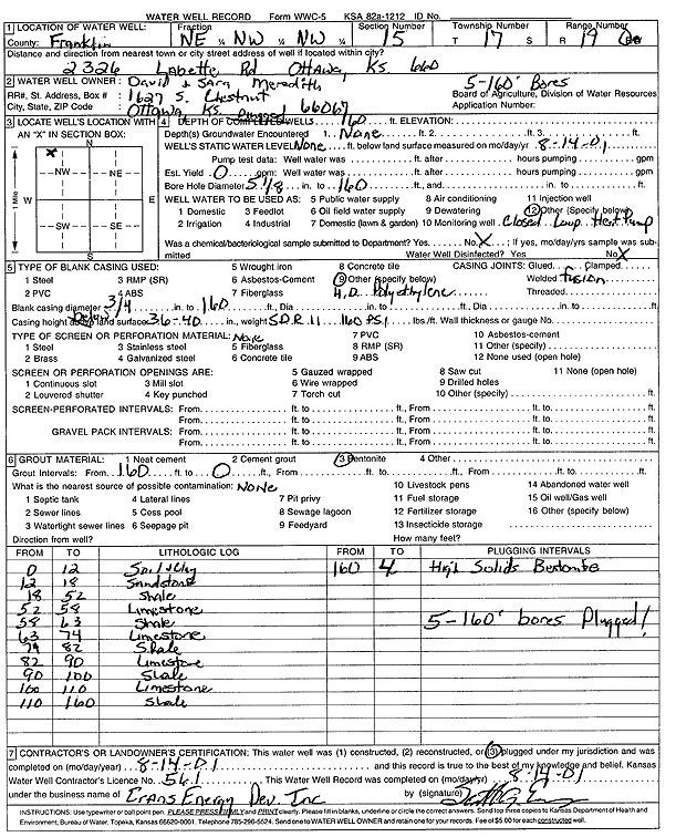
| Owner: Meredith, David and Sara | Status: Constructed | ||
| Location: T17S, R19E, Sec. 15, NE NW NW | County: Franklin | ||
| Directions: 2326 Labette Rd, Ottawa (five 160-foot bores) | |||
| Latitude: 38.5783727 | Longitude: -95.301173 | Datum NAD 27 | |
| Latitude: 38.5783849 | Longitude: -95.3014256 | Datum NAD 83 | |
| Longitude and latitude calculated by Survey from township-range-section-quarter calls. Only good to within the quarter call accuracy. | |||
| View well on interactive map | |||
| General Info | ||
| Well Depth: 160 ft. | Elevation: ft. | |
| Static Water Level: ft. | Est. Yield: gpm. | |
| Comp. Date: 14-Aug-2001 | Well Use: Heat Pump (Closed Loop/Disposal), Geothermal | |
| DWR Applic. #: | Other ID: | |
| Driller Info | ||
| Driller: Evans Energy Development, Inc. | License #: 561 | |
| Scanned Form | View scan |
|
Chemical Sample Submitted?:
Water Well disinfected?: | ||
| Casing Info | ||
| Casing Type:
Casing Joints: |
Diam: in. to ft | |
| Casing height above land surface: in
Casing Weight: lbs/ft Wall thickness or gauge no.: | ||
| Screen and Perforation Info | ||
| Screen Type: | Screen Openings: | |
| Screen-perforated intervals | From: ft to ft | |
| Gravel pack intervals | From: ft to ft | |
| Grout Info | ||
| Grout used: | From: to ft | |
| Source of Possible Contamination | ||
| Source: | ||
| Direction from well: | Distance: ft | |
| Lithologic Log
(Log data entered by KGS.) | ||
| From: 0 ft. to 12 ft. | soil and clay | |
| From: 12 ft. to 18 ft. | sandstone | |
| From: 18 ft. to 52 ft. | shale | |
| From: 52 ft. to 58 ft. | limestone | |
| From: 58 ft. to 63 ft. | shale | |
| From: 63 ft. to 74 ft. | limestone | |
| From: 74 ft. to 82 ft. | shale | |
| From: 82 ft. to 90 ft. | limestone | |
| From: 90 ft. to 100 ft. | shale | |
| From: 100 ft. to 110 ft. | limestone | |
| From: 110 ft. to 160 ft. | shale | |