|
|
|
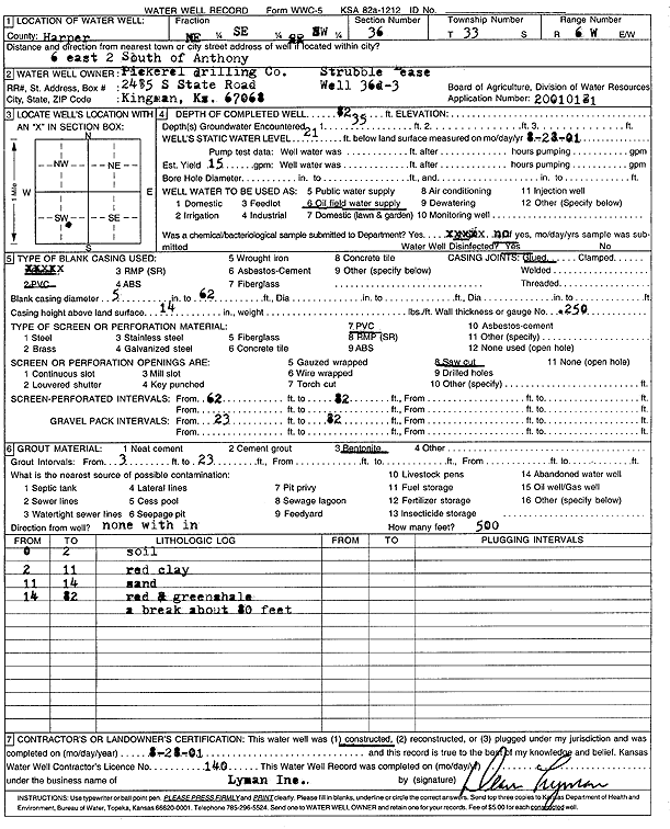
Specific Water Well Detail |
|
|
| Location Info | |||
| Owner: Pickrell Drilling Co. | Status: Constructed | ||
| Location: T33S, R6W, Sec. 36, NE SE SW | County: Harper | ||
| Directions: 6 mi E, 2 mi S of Anthony | |||
| Latitude: 37.1268297 | Longitude: -97.9215755 | Datum NAD 27 | |
| Latitude: 37.1268523 | Longitude: -97.9219118 | Datum NAD 83 | |
| Longitude and latitude calculated by Survey from township-range-section-quarter calls. Only good to within the quarter call accuracy. | |||
| View well on interactive map | |||
| General Info | ||
| Well Depth: 82 ft. | Elevation: ft. | |
| Static Water Level: 21 ft. | Est. Yield: 15 gpm. | |
| Comp. Date: 28-Aug-2001 | Well Use: Oil Field Water Supply | |
| DWR Applic. #: 20010181 | Other ID: Strubble 36 D 3 | |
| Links | |
| No Wizard information available. | |
| View info from WIMAS Water Right Data base... | |
| Driller Info | ||
| Driller: Dean L. Lyman, Inc. | License #: 140 | |
| Scanned Form | View scan |
|
Chemical Sample Submitted?:
Water Well disinfected?: | ||
| Casing Info | ||
| Casing Type:
Casing Joints: |
Diam: in. to ft | |
| Casing height above land surface: in
Casing Weight: lbs/ft Wall thickness or gauge no.: | ||
| Screen and Perforation Info | ||
| Screen Type: | Screen Openings: | |
| Screen-perforated intervals | From: ft to ft | |
| Gravel pack intervals | From: ft to ft | |
| Grout Info | ||
| Grout used: | From: to ft | |
| Source of Possible Contamination | ||
| Source: | ||
| Direction from well: | Distance: ft | |
| Lithologic Log
(Log data entered by KGS.) | ||
| From: 0 ft. to 2 ft. | soil | |
| From: 2 ft. to 11 ft. | red clay | |
| From: 11 ft. to 14 ft. | sand | |
| From: 14 ft. to 82 ft. | red and green shale with a break at 80 feet | |