|
|
|
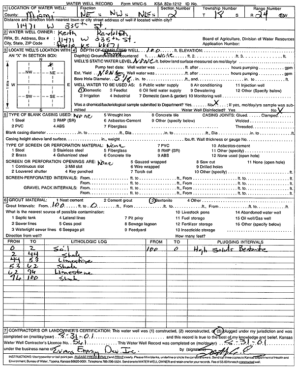
Specific Water Well Detail |
|
|
| Location Info | |||
| Owner: Randolph, Keith | Status: Plugged | ||
| Location: T18S, R24E, Sec. 2, NE NW NE | County: Miami | ||
| Directions: 11471 W 335th St, Paola | |||
| Latitude: 38.5189375 | Longitude: -94.7195157 | Datum NAD 27 | |
| Latitude: 38.5189521 | Longitude: -94.7197513 | Datum NAD 83 | |
| Longitude and latitude calculated by Survey from township-range-section-quarter calls. Only good to within the quarter call accuracy. | |||
| View well on interactive map | |||
| General Info | ||
| Well Depth: 100 ft. | Elevation: ft. | |
| Static Water Level: ft. | Est. Yield: gpm. | |
| Comp. Date: 31-Aug-2001 | Well Use: Domestic | |
| DWR Applic. #: | Other ID: | |
| Driller Info | ||
| Driller: Evans Energy Development, Inc. | License #: 561 | |
| Scanned Form | View scan |
| Casing Info | ||
|
Casing Type:
Diam: in. Casing height above land surface: in | ||
| Grout Info | ||
| Grout used: | From: to ft | |
| Source of Possible Contamination | ||
| Source: | ||
| Direction from well: | Distance: ft | |