|
|
|
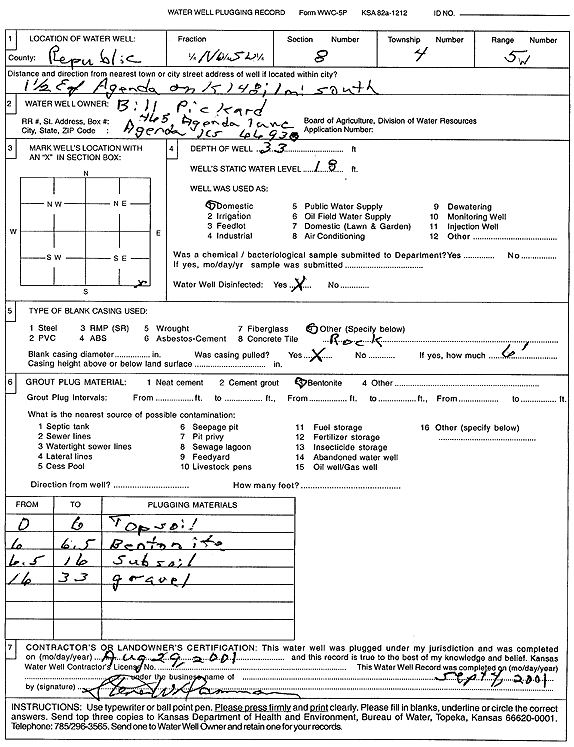
Specific Water Well Detail |
|
|
| Location Info | |||
| Owner: Pickard, Bill | Status: Plugged | ||
| Location: T4S, R5W, Sec. 8, NW SW | County: Republic | ||
| Directions: from Agenda: 1.5 m E on K 148, 1 mi S | |||
| Latitude: 39.717406 | Longitude: -97.9105045 | Datum NAD 27 | |
| Latitude: 39.7174137 | Longitude: -97.9108267 | Datum NAD 83 | |
| Longitude and latitude calculated by Survey from township-range-section-quarter calls. Only good to within the quarter call accuracy. | |||
| View well on interactive map | |||
| General Info | ||
| Well Depth: 33 ft. | Elevation: ft. | |
| Static Water Level: 18 ft. | Est. Yield: gpm. | |
| Comp. Date: 29-Aug-2001 | Well Use: Domestic | |
| DWR Applic. #: | Other ID: | |
| Driller Info | ||
| Driller: Steven W. Darman | License #: | |
| Scanned Form | View scan |
| Casing Info | ||
|
Casing Type:
Diam: in. Casing height above land surface: in | ||
| Grout Info | ||
| Grout used: | From: to ft | |
| Source of Possible Contamination | ||
| Source: | ||
| Direction from well: | Distance: ft | |