|
|
|
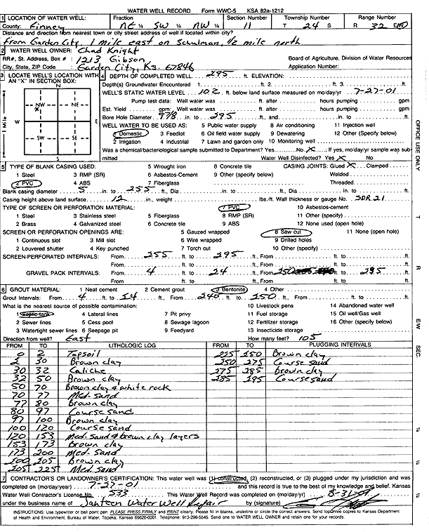
Specific Water Well Detail |
|
|
| Location Info | |||
| Owner: Knight, Chad | Status: Constructed | ||
| Location: T24S, R32W, Sec. 11, NE SW NW | County: Finney | ||
| Directions: from Garden City: 1 mi E on Schulman, .5 mi N | |||
| Latitude: 37.9847154 | Longitude: -100.806731 | Datum NAD 27 | |
| Latitude: 37.9847379 | Longitude: -100.8071678 | Datum NAD 83 | |
| Longitude and latitude calculated by Survey from township-range-section-quarter calls. Only good to within the quarter call accuracy. | |||
| View well on interactive map | |||
| General Info | ||
| Well Depth: 295 ft. | Elevation: ft. | |
| Static Water Level: 102 ft. | Est. Yield: gpm. | |
| Comp. Date: 27-Jul-2001 | Well Use: Domestic | |
| DWR Applic. #: | Other ID: | |
| Driller Info | ||
| Driller: Ed Jantzen Water Well Repair | License #: 533 | |
| Scanned Form | View scan |
|
Chemical Sample Submitted?:
Water Well disinfected?: | ||
| Casing Info | ||
| Casing Type:
Casing Joints: |
Diam: in. to ft | |
| Casing height above land surface: in
Casing Weight: lbs/ft Wall thickness or gauge no.: | ||
| Screen and Perforation Info | ||
| Screen Type: | Screen Openings: | |
| Screen-perforated intervals | From: ft to ft | |
| Gravel pack intervals | From: ft to ft | |
| Grout Info | ||
| Grout used: | From: to ft | |
| Source of Possible Contamination | ||
| Source: | ||
| Direction from well: | Distance: ft | |
| Lithologic Log
(Log data entered by KGS.) | ||
| From: 0 ft. to 2 ft. | topsoil | |
| From: 2 ft. to 30 ft. | brown clay | |
| From: 30 ft. to 32 ft. | caliche | |
| From: 32 ft. to 50 ft. | brown clay | |
| From: 50 ft. to 70 ft. | brown clay and white rock | |
| From: 70 ft. to 77 ft. | medium sand | |
| From: 77 ft. to 80 ft. | brown clay | |
| From: 80 ft. to 97 ft. | coarse sand | |
| From: 97 ft. to 100 ft. | brown clay | |
| From: 100 ft. to 120 ft. | coarse sand | |
| From: 120 ft. to 153 ft. | medium sand and brown clay layers | |
| From: 153 ft. to 173 ft. | brown clay | |
| From: 173 ft. to 200 ft. | medium sand | |
| From: 200 ft. to 205 ft. | brown clay | |
| From: 205 ft. to 225 ft. | medium sand | |
| From: 225 ft. to 250 ft. | brown clay | |
| From: 250 ft. to 275 ft. | coarse sand | |
| From: 275 ft. to 285 ft. | brown clay | |
| From: 285 ft. to 295 ft. | coarse sand | |