|
|
|
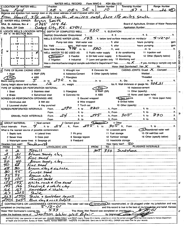
Specific Water Well Detail |
|
|
| Location Info | |||
| Owner: Smith, Bryan | Status: Constructed | ||
| Location: T27S, R26W, Sec. 10, NE NE SE | County: Ford | ||
| Directions: from Howell: 3.5 mi S, 2 mi E, 1.5 mi S | |||
| Latitude: 37.714352 | Longitude: -100.1431046 | Datum NAD 27 | |
| Latitude: 37.7143732 | Longitude: -100.1435208 | Datum NAD 83 | |
| Longitude and latitude calculated by Survey from township-range-section-quarter calls. Only good to within the quarter call accuracy. | |||
| View well on interactive map | |||
| General Info | ||
| Well Depth: 330 ft. | Elevation: ft. | |
| Static Water Level: 143 ft. | Est. Yield: gpm. | |
| Comp. Date: 12-May-2001 | Well Use: Domestic | |
| DWR Applic. #: | Other ID: | |
| Driller Info | ||
| Driller: Ed Jantzen Water Well Repair | License #: 533 | |
| Scanned Form | View scan |
|
Chemical Sample Submitted?:
Water Well disinfected?: | ||
| Casing Info | ||
| Casing Type:
Casing Joints: |
Diam: in. to ft | |
| Casing height above land surface: in
Casing Weight: lbs/ft Wall thickness or gauge no.: | ||
| Screen and Perforation Info | ||
| Screen Type: | Screen Openings: | |
| Screen-perforated intervals | From: ft to ft | |
| Gravel pack intervals | From: ft to ft | |
| Grout Info | ||
| Grout used: | From: to ft | |
| Source of Possible Contamination | ||
| Source: | ||
| Direction from well: | Distance: ft | |
| Lithologic Log
(Log data entered by KGS.) | ||
| From: 0 ft. to 2 ft. | topsoil | |
| From: 2 ft. to 21 ft. | brown sandy clay | |
| From: 21 ft. to 30 ft. | fine sand | |
| From: 30 ft. to 40 ft. | brown sandy clay | |
| From: 40 ft. to 68 ft. | fine sand | |
| From: 68 ft. to 80 ft. | brown clay and caliche | |
| From: 80 ft. to 95 ft. | coarse sand | |
| From: 95 ft. to 99 ft. | brown clay | |
| From: 99 ft. to 135 ft. | coarse sand | |
| From: 135 ft. to 145 ft. | white rock and fine sand | |
| From: 145 ft. to 166 ft. | sandrock and white clay | |
| From: 166 ft. to 167 ft. | limestone and shale | |
| From: 167 ft. to 223 ft. | shale | |
| From: 223 ft. to 250 ft. | shale and sandstone layers | |
| From: 250 ft. to 305 ft. | blue clay and rock ledges | |
| From: 305 ft. to 330 ft. | sandstone | |