|
|
|
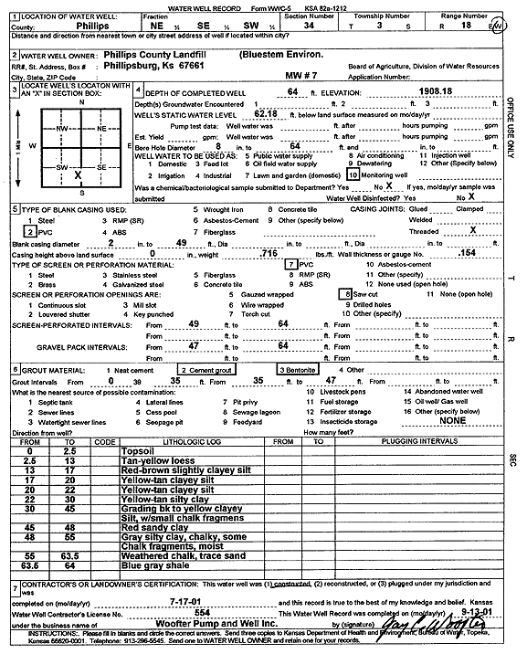
Specific Water Well Detail |
|
|
| Location Info | |||
| Owner: Phillips County Landfill | Status: Constructed | ||
| Location: T3S, R18W, Sec. 34, NE SE SW | County: Phillips | ||
| Directions: | |||
| Latitude: 39.7440308 | Longitude: -99.3382638 | Datum NAD 27 | |
| Latitude: 39.7440404 | Longitude: -99.3386387 | Datum NAD 83 | |
| Longitude and latitude calculated by Survey from township-range-section-quarter calls. Only good to within the quarter call accuracy. | |||
| View well on interactive map | |||
| General Info | ||
| Well Depth: 64 ft. | Elevation: 1908.18 ft. | |
| Static Water Level: 62.18 ft. | Est. Yield: gpm. | |
| Comp. Date: 17-Jul-2001 | Well Use: Monitoring well/observation/piezometer | |
| DWR Applic. #: | Other ID: MW 7 | |
| Driller Info | ||
| Driller: Jay C. Woofter Pump & Well, Inc. | License #: 554 | |
| Scanned Form | View scan |
|
Chemical Sample Submitted?:
Water Well disinfected?: | ||
| Casing Info | ||
| Casing Type:
Casing Joints: |
Diam: in. to ft | |
| Casing height above land surface: in
Casing Weight: lbs/ft Wall thickness or gauge no.: | ||
| Screen and Perforation Info | ||
| Screen Type: | Screen Openings: | |
| Screen-perforated intervals | From: ft to ft | |
| Gravel pack intervals | From: ft to ft | |
| Grout Info | ||
| Grout used: | From: to ft | |
| Source of Possible Contamination | ||
| Source: | ||
| Direction from well: | Distance: ft | |
| Lithologic Log
(Log data entered by KGS.) | ||
| From: 0 ft. to 2.5 ft. | topsoil | |
| From: 2.5 ft. to 13 ft. | tan-yellow loess | |
| From: 13 ft. to 17 ft. | red-brown slightly clayey silt | |
| From: 17 ft. to 20 ft. | yellow-tan clayey silt | |
| From: 20 ft. to 22 ft. | yellow-tan clayey silt | |
| From: 22 ft. to 30 ft. | yellow-tan silty clay | |
| From: 30 ft. to 45 ft. | grading black to yellow clayey silt, with small chalk fragments | |
| From: 45 ft. to 48 ft. | red sandy clay | |
| From: 48 ft. to 55 ft. | gray silty clay, chalky, some chalk fragments, moist | |
| From: 55 ft. to 63.5 ft. | weathered chalk, trace sand | |
| From: 63.5 ft. to 64 ft. | blue gray shale | |