|
|
|
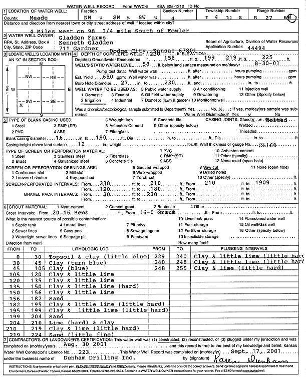
Specific Water Well Detail |
|
|
| Location Info | |||
| Owner: Gladden Farms | Status: Constructed | ||
| Location: T31S, R27W, Sec. 4, NW SW SW | County: Meade | ||
| Directions: from Fowler: 4 mi W on 98, .75 mi S | |||
| Latitude: 37.3752623 | Longitude: -100.271104 | Datum NAD 27 | |
| Latitude: 37.3752624 | Longitude: -100.2715254 | Datum NAD 83 | |
| Longitude and latitude calculated by Survey from township-range-section-quarter calls. Only good to within the quarter call accuracy. | |||
| View well on interactive map | |||
| General Info | ||
| Well Depth: 230 ft. | Elevation: ft. | |
| Static Water Level: 58 ft. | Est. Yield: 650 gpm. | |
| Comp. Date: 30-Aug-2001 | Well Use: Irrigation | |
| DWR Applic. #: 44494 | Other ID: | |
| Links | |
| No Wizard information available. | |
| View info from WIMAS Water Right Data base... | |
| Driller Info | ||
| Driller: Donald R. Dunham Drilling, Inc. | License #: 223 | |
| Scanned Form | View scan |
|
Chemical Sample Submitted?:
Water Well disinfected?: | ||
| Casing Info | ||
| Casing Type:
Casing Joints: |
Diam: in. to ft | |
| Casing height above land surface: in
Casing Weight: lbs/ft Wall thickness or gauge no.: | ||
| Screen and Perforation Info | ||
| Screen Type: | Screen Openings: | |
| Screen-perforated intervals | From: ft to ft | |
| Gravel pack intervals | From: ft to ft | |
| Grout Info | ||
| Grout used: | From: to ft | |
| Source of Possible Contamination | ||
| Source: | ||
| Direction from well: | Distance: ft | |
| Lithologic Log
(Log data entered by KGS.) | ||
| From: 0 ft. to 30 ft. | Topsoil and clay (little blue) | |
| From: 30 ft. to 45 ft. | Clay (turn blue) | |
| From: 45 ft. to 105 ft. | Clay (blue) | |
| From: 105 ft. to 120 ft. | Clay and little lime | |
| From: 120 ft. to 135 ft. | Clay and little lime | |
| From: 135 ft. to 150 ft. | Clay and little lime (hard) | |
| From: 150 ft. to 156 ft. | Clay and little lime | |
| From: 156 ft. to 182 ft. | Sand | |
| From: 182 ft. to 195 ft. | Clay and little lime (little hard) | |
| From: 195 ft. to 199 ft. | Clay and little lime (little hard) | |
| From: 199 ft. to 204 ft. | Sand | |
| From: 204 ft. to 210 ft. | Lime (hard) and clay | |
| From: 210 ft. to 219 ft. | Clay and lime (little hard) | |
| From: 219 ft. to 224 ft. | Sand (little fine) | |
| From: 224 ft. to 240 ft. | Clay and little lime (little hard) | |
| From: 240 ft. to 248 ft. | Clay and little lime (little hard) | |
| From: 248 ft. to 255 ft. | Clay and lime (little hard) | |