|
|
|
Specific Water Well Detail |
|
|
| Location Info | |||
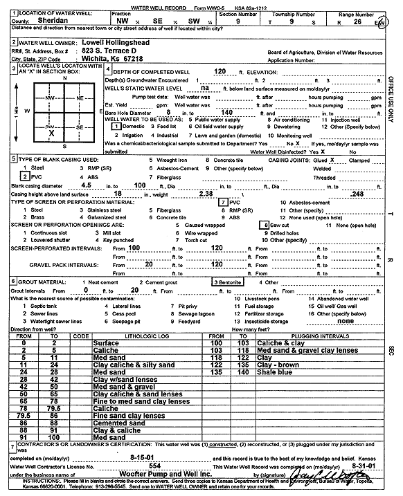
| Owner: Hollingshead, Lowell | Status: Constructed | ||
| Location: T9S, R26W, Sec. 9, NW SE SW | County: Sheridan | ||
| Directions: | |||
| Latitude: 39.2797979 | Longitude: -100.2314761 | Datum NAD 27 | |
| Latitude: 39.2798024 | Longitude: -100.2318889 | Datum NAD 83 | |
| Longitude and latitude calculated by Survey from township-range-section-quarter calls. Only good to within the quarter call accuracy. | |||
| View well on interactive map | |||
| General Info | ||
| Well Depth: 120 ft. | Elevation: ft. | |
| Static Water Level: ft. | Est. Yield: gpm. | |
| Comp. Date: 15-Aug-2001 | Well Use: Domestic | |
| DWR Applic. #: | Other ID: | |
| Driller Info | ||
| Driller: Jay C. Woofter Pump & Well, Inc. | License #: 554 | |
| Scanned Form | View scan |
|
Chemical Sample Submitted?:
Water Well disinfected?: | ||
| Casing Info | ||
| Casing Type:
Casing Joints: |
Diam: in. to ft | |
| Casing height above land surface: in
Casing Weight: lbs/ft Wall thickness or gauge no.: | ||
| Screen and Perforation Info | ||
| Screen Type: | Screen Openings: | |
| Screen-perforated intervals | From: ft to ft | |
| Gravel pack intervals | From: ft to ft | |
| Grout Info | ||
| Grout used: | From: to ft | |
| Source of Possible Contamination | ||
| Source: | ||
| Direction from well: | Distance: ft | |
| Lithologic Log
(Log data entered by KGS.) | ||
| From: 0 ft. to 2 ft. | Surface | |
| From: 2 ft. to 5 ft. | Caliche | |
| From: 5 ft. to 11 ft. | Medium sand | |
| From: 11 ft. to 24 ft. | Clay caliche and silty sand | |
| From: 24 ft. to 28 ft. | Medium sand | |
| From: 28 ft. to 42 ft. | Clay with sand lenses | |
| From: 42 ft. to 50 ft. | Medium sand and gravel | |
| From: 50 ft. to 65 ft. | Clay caliche and sand lenses | |
| From: 65 ft. to 78 ft. | Fine to medium sand clay lenses | |
| From: 78 ft. to 79.5 ft. | Caliche | |
| From: 79.5 ft. to 86 ft. | Fine sand clay lenses | |
| From: 86 ft. to 88 ft. | Cemented sand | |
| From: 88 ft. to 91 ft. | Clay and caliche | |
| From: 91 ft. to 100 ft. | Medium sand | |
| From: 100 ft. to 103 ft. | Caliche and clay | |
| From: 103 ft. to 118 ft. | Medium sand and gravel clay lenses | |
| From: 118 ft. to 122 ft. | Clay | |
| From: 122 ft. to 135 ft. | Clay, brown | |
| From: 135 ft. to 140 ft. | Shale blue | |