|
|
|
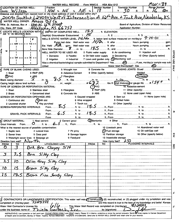
Specific Water Well Detail |
|
|
| Location Info | |||
| Owner: Amoco Oil Co. | Status: Constructed | ||
| Location: T30S, R16E, Sec. 19, NW NE NE | County: Wilson | ||
| Directions: from 12th Ave and Tank Ave: 200' S, 1240' W | |||
| Latitude: 37.4274656 | Longitude: -95.6914231 | Datum NAD 27 | |
| Latitude: 37.4275248 | Longitude: -95.6916812 | Datum NAD 83 | |
| Longitude and latitude calculated by Survey from township-range-section-quarter calls. Only good to within the quarter call accuracy. | |||
| View well on interactive map | |||
| General Info | ||
| Well Depth: 18.5 ft. | Elevation: ft. | |
| Static Water Level: 14.66 ft. | Est. Yield: gpm. | |
| Comp. Date: 25-Jul-2001 | Well Use: Monitoring well/observation/piezometer | |
| DWR Applic. #: | Other ID: MW 89 | |
| Driller Info | ||
| Driller: Thiele Geotech, Inc. | License #: 616 | |
| Scanned Form | View scan |
|
Chemical Sample Submitted?:
Water Well disinfected?: | ||
| Casing Info | ||
| Casing Type:
Casing Joints: |
Diam: in. to ft | |
| Casing height above land surface: in
Casing Weight: lbs/ft Wall thickness or gauge no.: | ||
| Screen and Perforation Info | ||
| Screen Type: | Screen Openings: | |
| Screen-perforated intervals | From: ft to ft | |
| Gravel pack intervals | From: ft to ft | |
| Grout Info | ||
| Grout used: | From: to ft | |
| Source of Possible Contamination | ||
| Source: | ||
| Direction from well: | Distance: ft | |
| Lithologic Log
(Log data entered by KGS.) | ||
| From: 0 ft. to 3 ft. | dark brown clayey silt | |
| From: 3 ft. to 7.5 ft. | brown silty clay | |
| From: 7.5 ft. to 10 ft. | olive gray silty clay | |
| From: 10 ft. to 15 ft. | brown silty clay | |
| From: 15 ft. to 18.5 ft. | brown fine sandy clay | |