|
|
|
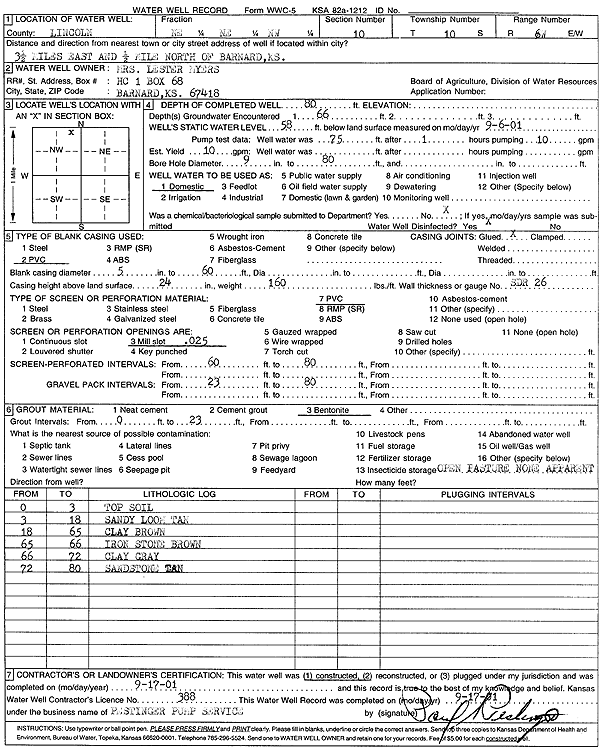
Specific Water Well Detail |
|
|
| Location Info | |||
| Owner: Myers, Mrs. Lester | Status: Constructed | ||
| Location: T10S, R6W, Sec. 10, NE NE NW | County: Lincoln | ||
| Directions: from Barnard: 3.5 mi E and 0.5 mi N | |||
| Latitude: 39.2036364 | Longitude: -97.977819 | Datum NAD 27 | |
| Latitude: 39.2036404 | Longitude: -97.9781413 | Datum NAD 83 | |
| Longitude and latitude calculated by Survey from township-range-section-quarter calls. Only good to within the quarter call accuracy. | |||
| View well on interactive map | |||
| General Info | ||
| Well Depth: 80 ft. | Elevation: ft. | |
| Static Water Level: 58 ft. | Est. Yield: 10 gpm. | |
| Comp. Date: 17-Sep-2001 | Well Use: Domestic | |
| DWR Applic. #: | Other ID: | |
| Driller Info | ||
| Driller: Paul Pestinger Pump & Water Well Drlg., Inc. | License #: 388 | |
| Scanned Form | View scan |
|
Chemical Sample Submitted?:
Water Well disinfected?: | ||
| Casing Info | ||
| Casing Type:
Casing Joints: |
Diam: in. to ft | |
| Casing height above land surface: in
Casing Weight: lbs/ft Wall thickness or gauge no.: | ||
| Screen and Perforation Info | ||
| Screen Type: | Screen Openings: | |
| Screen-perforated intervals | From: ft to ft | |
| Gravel pack intervals | From: ft to ft | |
| Grout Info | ||
| Grout used: | From: to ft | |
| Source of Possible Contamination | ||
| Source: | ||
| Direction from well: | Distance: ft | |
| Lithologic Log
(Log data entered by KGS.) | ||
| From: 0 ft. to 3 ft. | top soil | |
| From: 3 ft. to 18 ft. | sandy loam, tan | |
| From: 18 ft. to 65 ft. | clay, brown | |
| From: 65 ft. to 66 ft. | ironstone, brown | |
| From: 66 ft. to 72 ft. | clay, gray | |
| From: 72 ft. to 80 ft. | sandstone, tan | |