|
|
|
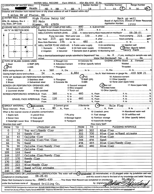
Specific Water Well Detail |
|
|
| Location Info | |||
| Owner: High Plains Dairy LLC | Status: Constructed | ||
| Location: T33S, R30W, Sec. 18, NE NW SE | County: Meade | ||
| Directions: from Plains, 5 mi SW | |||
| Latitude: 37.1764183 | Longitude: -100.6222893 | Datum NAD 27 | |
| Latitude: 37.1764408 | Longitude: -100.622721 | Datum NAD 83 | |
| Longitude and latitude calculated by Survey from township-range-section-quarter calls. Only good to within the quarter call accuracy. | |||
| View well on interactive map | |||
| General Info | ||
| Well Depth: 480 ft. | Elevation: ft. | |
| Static Water Level: 230 ft. | Est. Yield: gpm. | |
| Comp. Date: 28-Aug-2001 | Well Use: Feedlot | |
| DWR Applic. #: 12332 | Other ID: | |
| Links | |
| No Wizard information available. | |
| View info from WIMAS Water Right Data base... | |
| Driller Info | ||
| Driller: Howard Drilling Company AG, LLC | License #: 430 | |
| Scanned Form | View scan |
|
Chemical Sample Submitted?:
Water Well disinfected?: | ||
| Casing Info | ||
| Casing Type:
Casing Joints: |
Diam: in. to ft | |
| Casing height above land surface: in
Casing Weight: lbs/ft Wall thickness or gauge no.: | ||
| Screen and Perforation Info | ||
| Screen Type: | Screen Openings: | |
| Screen-perforated intervals | From: ft to ft | |
| Gravel pack intervals | From: ft to ft | |
| Grout Info | ||
| Grout used: | From: to ft | |
| Source of Possible Contamination | ||
| Source: | ||
| Direction from well: | Distance: ft | |
| Lithologic Log
(Log data entered by KGS.) | ||
| From: 0 ft. to 2 ft. | top soil/sandy clay | |
| From: 2 ft. to 16 ft. | sandy clay | |
| From: 16 ft. to 43 ft. | caliche clay | |
| From: 43 ft. to 66 ft. | caliche clay/tan clay | |
| From: 66 ft. to 76 ft. | sand | |
| From: 76 ft. to 90 ft. | caliche clay/sandy clay | |
| From: 90 ft. to 109 ft. | caliche clay | |
| From: 109 ft. to 144 ft. | sand | |
| From: 144 ft. to 157 ft. | caliche clay/sandy clay | |
| From: 157 ft. to 170 ft. | sandy clay | |
| From: 170 ft. to 182 ft. | sand | |
| From: 182 ft. to 223 ft. | blue/sandy clay | |
| From: 223 ft. to 240 ft. | sand with clay streaks | |
| From: 240 ft. to 260 ft. | sand | |
| From: 260 ft. to 302 ft. | blue clay | |
| From: 302 ft. to 320 ft. | blue clay with sand streaks | |
| From: 320 ft. to 344 ft. | blue clay | |
| From: 344 ft. to 456 ft. | sand | |
| From: 456 ft. to 465 ft. | blue clay/sandy clay | |
| From: 465 ft. to 480 ft. | blue clay | |