|
|
|
Specific Water Well Detail |
|
|
| Location Info | |||
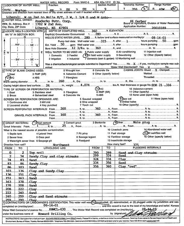
| Owner: Anadarko Petroleum Corp. | Status: Constructed | ||
| Location: T35S, R40W, Sec. 9, SE SE SE | County: Morton | ||
| Directions: from Liberal: W on 2nd to Rolla B/T, 2 mi W, 1.75 S, W into site | |||
| Latitude: 37.0116945 | Longitude: -101.6646727 | Datum NAD 27 | |
| Latitude: 37.0117204 | Longitude: -101.6651116 | Datum NAD 83 | |
| Longitude and latitude calculated by Survey from township-range-section-quarter calls. Only good to within the quarter call accuracy. | |||
| View well on interactive map | |||
| General Info | ||
| Well Depth: 360 ft. | Elevation: ft. | |
| Static Water Level: 280 ft. | Est. Yield: 50 gpm. | |
| Comp. Date: 14-Aug-2001 | Well Use: Oil Field Water Supply | |
| DWR Applic. #: 20010189 | Other ID: Gerber 4 | |
| Links | |
| No Wizard information available. | |
| View info from WIMAS Water Right Data base... | |
| Driller Info | ||
| Driller: Howard Drilling Company AG, LLC | License #: 430 | |
| Scanned Form | View scan |
|
Chemical Sample Submitted?:
Water Well disinfected?: | ||
| Casing Info | ||
| Casing Type:
Casing Joints: |
Diam: in. to ft | |
| Casing height above land surface: in
Casing Weight: lbs/ft Wall thickness or gauge no.: | ||
| Screen and Perforation Info | ||
| Screen Type: | Screen Openings: | |
| Screen-perforated intervals | From: ft to ft | |
| Gravel pack intervals | From: ft to ft | |
| Grout Info | ||
| Grout used: | From: to ft | |
| Source of Possible Contamination | ||
| Source: | ||
| Direction from well: | Distance: ft | |
| Lithologic Log
(Log data entered by KGS.) | ||
| From: 0 ft. to 2 ft. | top soil | |
| From: 2 ft. to 74 ft. | sandy clay and clay streaks | |
| From: 74 ft. to 83 ft. | sand | |
| From: 83 ft. to 86 ft. | sandy clay | |
| From: 86 ft. to 103 ft. | sand | |
| From: 103 ft. to 136 ft. | clay and sandy clay | |
| From: 136 ft. to 151 ft. | clay | |
| From: 151 ft. to 163 ft. | sand | |
| From: 163 ft. to 178 ft. | clay | |
| From: 178 ft. to 208 ft. | sand | |
| From: 208 ft. to 222 ft. | clay | |
| From: 222 ft. to 240 ft. | sand | |
| From: 240 ft. to 259 ft. | clay and sand streaks | |
| From: 259 ft. to 290 ft. | clay | |
| From: 290 ft. to 299 ft. | sand and clay streaks | |
| From: 299 ft. to 324 ft. | sand | |
| From: 324 ft. to 334 ft. | clay | |
| From: 334 ft. to 356 ft. | sand | |
| From: 356 ft. to 360 ft. | clay red | |