|
|
|
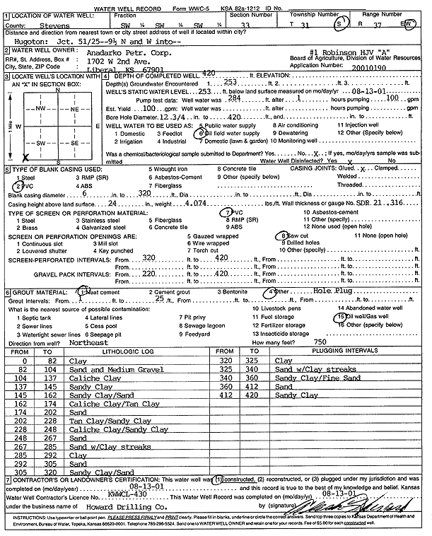
Specific Water Well Detail |
|
|
| Location Info | |||
| Owner: Anadarko Petroleum Corp. | Status: Constructed | ||
| Location: T31S, R37W, Sec. 33, SW SW SW | County: Stevens | ||
| Directions: from Hugoton junction 51/25: 9.5 mi N, W into site | |||
| Latitude: 37.3017161 | Longitude: -101.3558656 | Datum NAD 27 | |
| Latitude: 37.3017396 | Longitude: -101.3563025 | Datum NAD 83 | |
| Longitude and latitude calculated by Survey from township-range-section-quarter calls. Only good to within the quarter call accuracy. | |||
| View well on interactive map | |||
| General Info | ||
| Well Depth: 420 ft. | Elevation: ft. | |
| Static Water Level: 253 ft. | Est. Yield: 100 gpm. | |
| Comp. Date: 13-Aug-2001 | Well Use: Oil Field Water Supply | |
| DWR Applic. #: 2001090 | Other ID: HVJ Robinson A-1 | |
| Links | |
| No Wizard information available. | |
| View info from WIMAS Water Right Data base... | |
| Driller Info | ||
| Driller: Howard Drilling Company AG, LLC | License #: 430 | |
| Scanned Form | View scan |
|
Chemical Sample Submitted?:
Water Well disinfected?: | ||
| Casing Info | ||
| Casing Type:
Casing Joints: |
Diam: in. to ft | |
| Casing height above land surface: in
Casing Weight: lbs/ft Wall thickness or gauge no.: | ||
| Screen and Perforation Info | ||
| Screen Type: | Screen Openings: | |
| Screen-perforated intervals | From: ft to ft | |
| Gravel pack intervals | From: ft to ft | |
| Grout Info | ||
| Grout used: | From: to ft | |
| Source of Possible Contamination | ||
| Source: | ||
| Direction from well: | Distance: ft | |
| Lithologic Log
(Log data entered by KGS.) | ||
| From: 0 ft. to 82 ft. | clay | |
| From: 82 ft. to 104 ft. | sand and medium gravel | |
| From: 104 ft. to 137 ft. | caliche clay | |
| From: 137 ft. to 145 ft. | sandy clay | |
| From: 145 ft. to 162 ft. | sandy clay/sand | |
| From: 162 ft. to 174 ft. | caliche clay/tan clay | |
| From: 174 ft. to 202 ft. | sand | |
| From: 202 ft. to 228 ft. | tan clay/sandy clay | |
| From: 228 ft. to 248 ft. | caliche clay/sandy clay | |
| From: 248 ft. to 267 ft. | sand | |
| From: 267 ft. to 285 ft. | sand with clay streaks | |
| From: 285 ft. to 292 ft. | clay | |
| From: 292 ft. to 305 ft. | sand | |
| From: 305 ft. to 320 ft. | sandy clay/sand | |
| From: 320 ft. to 325 ft. | clay | |
| From: 325 ft. to 340 ft. | sand with clay streaks | |
| From: 340 ft. to 360 ft. | sandy clay/fine sand | |
| From: 360 ft. to 412 ft. | sand | |
| From: 412 ft. to 420 ft. | sandy clay | |