|
|
|
Specific Water Well Detail |
|
|
| Location Info | |||
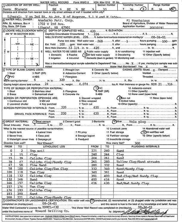
| Owner: Anadarko Petroleum Corp. | Status: Constructed | ||
| Location: T34S, R38W, Sec. 33, SE SE SE | County: Stevens | ||
| Directions: from Liberal: W on 2nd St to Jct S of Hugoton, 5.1 mi W, N into site | |||
| Latitude: 37.0401827 | Longitude: -101.4477315 | Datum NAD 27 | |
| Latitude: 37.0402096 | Longitude: -101.4481694 | Datum NAD 83 | |
| Longitude and latitude calculated by Survey from township-range-section-quarter calls. Only good to within the quarter call accuracy. | |||
| View well on interactive map | |||
| General Info | ||
| Well Depth: 420 ft. | Elevation: ft. | |
| Static Water Level: 226 ft. | Est. Yield: 100 gpm. | |
| Comp. Date: 24-Aug-2001 | Well Use: Oil Field Water Supply | |
| DWR Applic. #: 20010191 | Other ID: Brecheisen 1 | |
| Links | |
| No Wizard information available. | |
| View info from WIMAS Water Right Data base... | |
| Driller Info | ||
| Driller: Howard Drilling Company AG, LLC | License #: 430 | |
| Scanned Form | View scan |
|
Chemical Sample Submitted?:
Water Well disinfected?: | ||
| Casing Info | ||
| Casing Type:
Casing Joints: |
Diam: in. to ft | |
| Casing height above land surface: in
Casing Weight: lbs/ft Wall thickness or gauge no.: | ||
| Screen and Perforation Info | ||
| Screen Type: | Screen Openings: | |
| Screen-perforated intervals | From: ft to ft | |
| Gravel pack intervals | From: ft to ft | |
| Grout Info | ||
| Grout used: | From: to ft | |
| Source of Possible Contamination | ||
| Source: | ||
| Direction from well: | Distance: ft | |
| Lithologic Log
(Log data entered by KGS.) | ||
| From: 0 ft. to 2 ft. | top soil | |
| From: 2 ft. to 15 ft. | clay | |
| From: 15 ft. to 39 ft. | caliche clay | |
| From: 39 ft. to 47 ft. | caliche clay/sandy clay | |
| From: 47 ft. to 58 ft. | fine sand | |
| From: 58 ft. to 100 ft. | caliche clay/tan clay | |
| From: 100 ft. to 118 ft. | tan clay | |
| From: 118 ft. to 132 ft. | caliche clay | |
| From: 132 ft. to 146 ft. | sand | |
| From: 146 ft. to 157 ft. | caliche clay | |
| From: 157 ft. to 174 ft. | tan clay | |
| From: 174 ft. to 183 ft. | caliche clay | |
| From: 183 ft. to 200 ft. | sand | |
| From: 200 ft. to 221 ft. | caliche clay/sandy clay | |
| From: 221 ft. to 240 ft. | sand | |
| From: 240 ft. to 244 ft. | clay | |
| From: 244 ft. to 261 ft. | sand | |
| From: 261 ft. to 280 ft. | yellow clay/sand streaks | |
| From: 280 ft. to 332 ft. | sand | |
| From: 332 ft. to 340 ft. | sand/sandy clay | |
| From: 340 ft. to 391 ft. | sand | |
| From: 391 ft. to 400 ft. | red clay/red sandy clay | |
| From: 400 ft. to 416 ft. | sand | |
| From: 416 ft. to 420 ft. | red/red sandy clay | |