|
|
|
Specific Water Well Detail |
|
|
| Location Info | |||
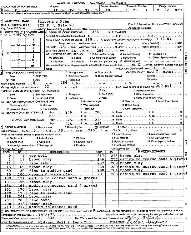
| Owner: Hahn, Silverina | Status: Constructed | ||
| Location: T23S, R32W, Sec. 18, SE SW SE | County: Finney | ||
| Directions: | |||
| Latitude: 38.0483978 | Longitude: -100.8709187 | Datum NAD 27 | |
| Latitude: 38.0484206 | Longitude: -100.8713569 | Datum NAD 83 | |
| Longitude and latitude calculated by Survey from township-range-section-quarter calls. Only good to within the quarter call accuracy. | |||
| View well on interactive map | |||
| General Info | ||
| Well Depth: 286 ft. | Elevation: ft. | |
| Static Water Level: 118 ft. | Est. Yield: 75 gpm. | |
| Comp. Date: 12-Sep-2001 | Well Use: Domestic | |
| DWR Applic. #: | Other ID: | |
| Links | |
| View info from Wizard Water Level Data base... | |
| No WIMAS information available. | |
| Driller Info | ||
| Driller: Midwest Well & Pump, Inc. | License #: 532 | |
| Scanned Form | View scan |
|
Chemical Sample Submitted?:
Water Well disinfected?: | ||
| Casing Info | ||
| Casing Type:
Casing Joints: |
Diam: in. to ft | |
| Casing height above land surface: in
Casing Weight: lbs/ft Wall thickness or gauge no.: | ||
| Screen and Perforation Info | ||
| Screen Type: | Screen Openings: | |
| Screen-perforated intervals | From: ft to ft | |
| Gravel pack intervals | From: ft to ft | |
| Grout Info | ||
| Grout used: | From: to ft | |
| Source of Possible Contamination | ||
| Source: | ||
| Direction from well: | Distance: ft | |
| Lithologic Log
(Log data entered by KGS.) | ||
| From: 0 ft. to 1 ft. | top soil | |
| From: 1 ft. to 11 ft. | brown clay | |
| From: 11 ft. to 15 ft. | fine sand | |
| From: 15 ft. to 69 ft. | brown clay | |
| From: 69 ft. to 80 ft. | fine to medium sand | |
| From: 80 ft. to 100 ft. | gypsum and brown clay | |
| From: 100 ft. to 131 ft. | medium to coarse sand and gravel | |
| From: 131 ft. to 156 ft. | brown clay | |
| From: 156 ft. to 161 ft. | medium to coarse sand and gravel | |
| From: 161 ft. to 170 ft. | brown clay | |
| From: 170 ft. to 198 ft. | fine to medium sand | |
| From: 198 ft. to 201 ft. | brown clay | |
| From: 201 ft. to 208 ft. | fine sand | |
| From: 208 ft. to 213 ft. | brown clay | |
| From: 213 ft. to 217 ft. | medium to coarse sand | |
| From: 217 ft. to 246 ft. | brown clay | |
| From: 246 ft. to 257 ft. | medium to coarse sand and gravel | |
| From: 257 ft. to 269 ft. | brown clay | |
| From: 269 ft. to 280 ft. | medium to coarse sand and gravel | |
| From: 280 ft. to 281 ft. | brown clay | |
| From: 281 ft. to 286 ft. | medium to coarse sand and gravel | |