|
|
|
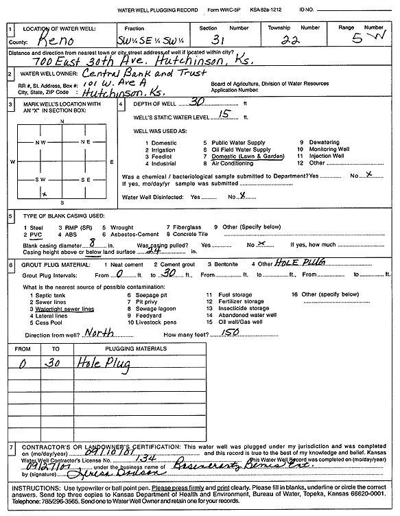
Specific Water Well Detail |
|
|
| Location Info | |||
| Owner: Central Bank and Trust | Status: Plugged | ||
| Location: T22S, R5W, Sec. 31, SW SE SW | County: Reno | ||
| Directions: 700 E 30th Ave, Hutchinson | |||
| Latitude: 38.0874601 | Longitude: -97.9159909 | Datum NAD 27 | |
| Latitude: 38.0874711 | Longitude: -97.9163204 | Datum NAD 83 | |
| Longitude and latitude calculated by Survey from township-range-section-quarter calls. Only good to within the quarter call accuracy. | |||
| View well on interactive map | |||
| General Info | ||
| Well Depth: 30 ft. | Elevation: ft. | |
| Static Water Level: 15 ft. | Est. Yield: gpm. | |
| Comp. Date: 10-Sep-2001 | Well Use: Domestic, Lawn and Garden | |
| DWR Applic. #: | Other ID: | |
| Driller Info | ||
| Driller: Rosencrantz-Bemis Enterprises, Inc. | License #: 134 | |
| Scanned Form | View scan |
| Casing Info | ||
|
Casing Type:
Diam: in. Casing height above land surface: in | ||
| Grout Info | ||
| Grout used: | From: to ft | |
| Source of Possible Contamination | ||
| Source: | ||
| Direction from well: | Distance: ft | |