|
|
|
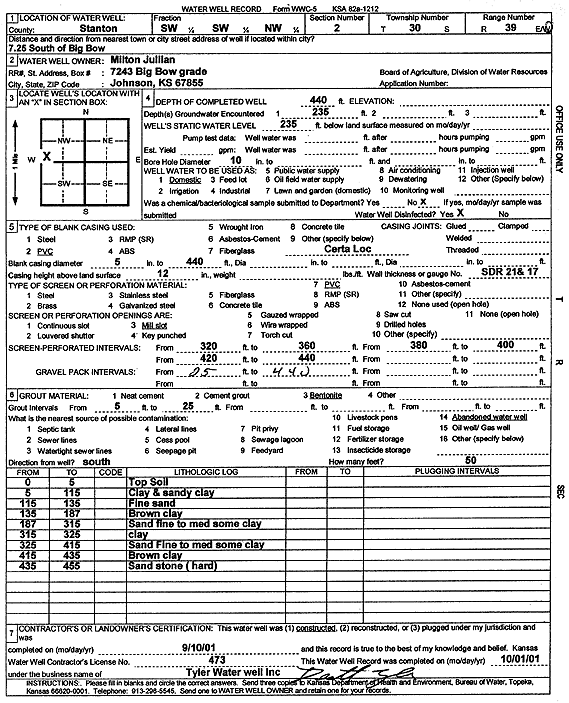
Specific Water Well Detail |
|
|
| Location Info | |||
| Owner: Jullian, Milton | Status: Constructed | ||
| Location: T30S, R39W, Sec. 2, SW SW NW | County: Stanton | ||
| Directions: from Big Bow: 7.25 mi S | |||
| Latitude: 37.4690105 | Longitude: -101.5607022 | Datum NAD 27 | |
| Latitude: 37.4690313 | Longitude: -101.5611475 | Datum NAD 83 | |
| Longitude and latitude calculated by Survey from township-range-section-quarter calls. Only good to within the quarter call accuracy. | |||
| View well on interactive map | |||
| General Info | ||
| Well Depth: 440 ft. | Elevation: ft. | |
| Static Water Level: 235 ft. | Est. Yield: gpm. | |
| Comp. Date: 10-Sep-2001 | Well Use: Domestic | |
| DWR Applic. #: | Other ID: | |
| Driller Info | ||
| Driller: Destal Tyler Water Well Service | License #: 473 | |
| Scanned Form | View scan |
|
Chemical Sample Submitted?:
Water Well disinfected?: | ||
| Casing Info | ||
| Casing Type:
Casing Joints: |
Diam: in. to ft | |
| Casing height above land surface: in
Casing Weight: lbs/ft Wall thickness or gauge no.: | ||
| Screen and Perforation Info | ||
| Screen Type: | Screen Openings: | |
| Screen-perforated intervals | From: ft to ft | |
| Gravel pack intervals | From: ft to ft | |
| Grout Info | ||
| Grout used: | From: to ft | |
| Source of Possible Contamination | ||
| Source: | ||
| Direction from well: | Distance: ft | |
| Lithologic Log
(Log data entered by KGS.) | ||
| From: 0 ft. to 5 ft. | top soil | |
| From: 5 ft. to 115 ft. | clay and sandy clay | |
| From: 115 ft. to 135 ft. | fine sand | |
| From: 135 ft. to 187 ft. | brown clay | |
| From: 187 ft. to 315 ft. | sand fine to medium some clay | |
| From: 315 ft. to 325 ft. | clay | |
| From: 325 ft. to 415 ft. | sand fine to medium some clay | |
| From: 415 ft. to 435 ft. | brown clay | |
| From: 435 ft. to 455 ft. | sandstone (hard) | |