|
|
|
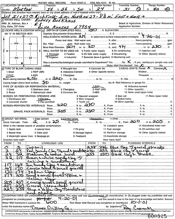
Specific Water Well Detail |
|
|
| Location Info | |||
| Owner: Boekhaus, Rodney | Status: Constructed | ||
| Location: T31S, R40W, Sec. 24, SE SE SW | County: Morton | ||
| Directions: from Jct 51 and 27 in Richfield: 5 miles North on 27, 8.5 miles East, then North into site | |||
| Latitude: 37.3312976 | Longitude: -101.6201988 | Datum NAD 27 | |
| Latitude: 37.3313201 | Longitude: -101.6206405 | Datum NAD 83 | |
| Longitude and latitude calculated by Survey from township-range-section-quarter calls. Only good to within the quarter call accuracy. | |||
| View well on interactive map | |||
| General Info | ||
| Well Depth: 280 ft. | Elevation: ft. | |
| Static Water Level: 214 ft. | Est. Yield: gpm. | |
| Comp. Date: 20-Sep-2001 | Well Use: Domestic | |
| DWR Applic. #: | Other ID: | |
| Driller Info | ||
| Driller: Ray Cramer Drilling Co. | License #: 600 | |
| Scanned Form | View scan |
|
Chemical Sample Submitted?:
Water Well disinfected?: | ||
| Casing Info | ||
| Casing Type:
Casing Joints: |
Diam: in. to ft | |
| Casing height above land surface: in
Casing Weight: lbs/ft Wall thickness or gauge no.: | ||
| Screen and Perforation Info | ||
| Screen Type: | Screen Openings: | |
| Screen-perforated intervals | From: ft to ft | |
| Gravel pack intervals | From: ft to ft | |
| Grout Info | ||
| Grout used: | From: to ft | |
| Source of Possible Contamination | ||
| Source: | ||
| Direction from well: | Distance: ft | |
| Lithologic Log
(Log data entered by KGS.) | ||
| From: 0 ft. to 3 ft. | topsoil | |
| From: 3 ft. to 24 ft. | tan sandy clay with sand and sandstone | |
| From: 24 ft. to 32 ft. | medium to coarse sand | |
| From: 32 ft. to 117 ft. | brown and white sandy clay w/caliche and sandstone | |
| From: 117 ft. to 164 ft. | tan sandy clay and sandstone | |
| From: 164 ft. to 170 ft. | coarse sand and small gravel | |
| From: 170 ft. to 174 ft. | yellow clay | |
| From: 174 ft. to 205 ft. | sand and small gravel w/blue and yellow clay | |
| From: 205 ft. to 217 ft. | coarse sand and small gravel | |
| From: 217 ft. to 227 ft. | gravel (cemented) | |
| From: 227 ft. to 238 ft. | blue and yellow clay with sandstone and shale | |
| From: 238 ft. to 246 ft. | blue clay w/gravel streaks | |
| From: 246 ft. to 253 ft. | black clay with gravel | |
| From: 253 ft. to 280 ft. | black clay and shale | |