|
|
|
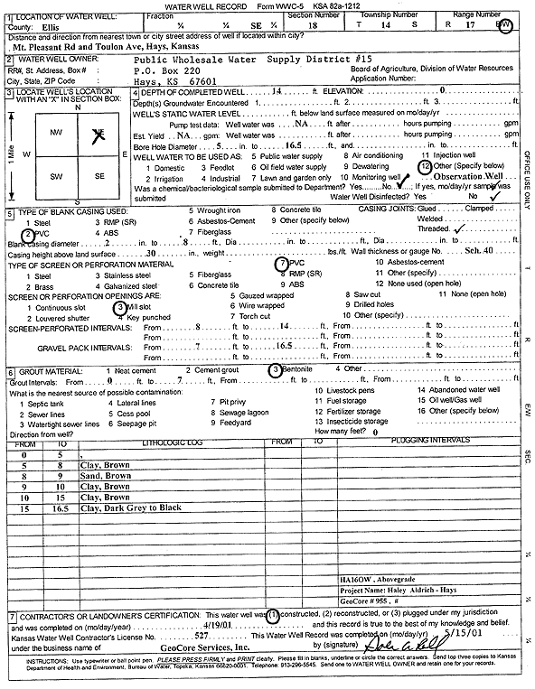
Specific Water Well Detail |
|
|
| Location Info | |||
| Owner: Public Wholesale Water Supply District 15 | Status: Constructed | ||
| Location: T14S, R17W, Sec. 18, SE | County: Ellis | ||
| Directions: Mt Pleasant Rd and Toulon Ave, Hays | |||
| Latitude: 38.8311184 | Longitude: -99.2484513 | Datum NAD 27 | |
| Latitude: 38.8311304 | Longitude: -99.2488299 | Datum NAD 83 | |
| Longitude and latitude calculated by Survey from township-range-section-quarter calls. Only good to within the quarter call accuracy. | |||
| View well on interactive map | |||
| General Info | ||
| Well Depth: 14 ft. | Elevation: ft. | |
| Static Water Level: ft. | Est. Yield: gpm. | |
| Comp. Date: 19-Apr-2001 | Well Use: Monitoring well/observation/piezometer | |
| DWR Applic. #: | Other ID: HA 16 OW | |
| Driller Info | ||
| Driller: GeoCore Services Inc. | License #: 527 | |
| Scanned Form | View scan |
|
Chemical Sample Submitted?:
Water Well disinfected?: | ||
| Casing Info | ||
| Casing Type:
Casing Joints: |
Diam: in. to ft | |
| Casing height above land surface: in
Casing Weight: lbs/ft Wall thickness or gauge no.: | ||
| Screen and Perforation Info | ||
| Screen Type: | Screen Openings: | |
| Screen-perforated intervals | From: ft to ft | |
| Gravel pack intervals | From: ft to ft | |
| Grout Info | ||
| Grout used: | From: to ft | |
| Source of Possible Contamination | ||
| Source: | ||
| Direction from well: | Distance: ft | |
| Lithologic Log
(Log data entered by KGS.) | ||
| From: 0 ft. to 5 ft. | top soil | |
| From: 5 ft. to 8 ft. | clay, brown | |
| From: 8 ft. to 9 ft. | sand, brown | |
| From: 9 ft. to 10 ft. | clay, brown | |
| From: 10 ft. to 15 ft. | clay, brown | |
| From: 15 ft. to 16.5 ft. | clay, dark gray to black | |