|
|
|
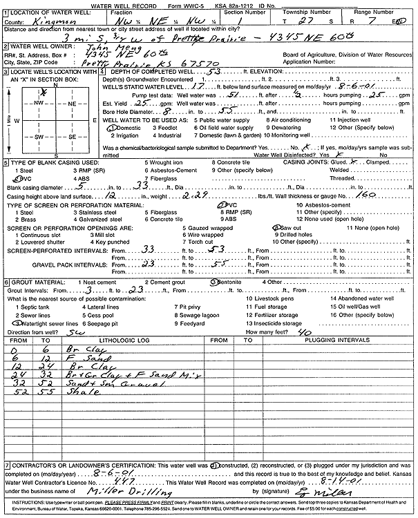
Specific Water Well Detail |
|
|
| Location Info | |||
| Owner: Meng, John | Status: Constructed | ||
| Location: T27S, R7W, Sec. 1, NW NE NW | County: Kingman | ||
| Directions: 4345 NE 60th, Pretty Prairie - from Pretty Prairie: 3 mi S, .75 mi W | |||
| Latitude: 37.7323322 | Longitude: -98.039457 | Datum NAD 27 | |
| Latitude: 37.7323464 | Longitude: -98.0397932 | Datum NAD 83 | |
| Longitude and latitude calculated by Survey from township-range-section-quarter calls. Only good to within the quarter call accuracy. | |||
| View well on interactive map | |||
| General Info | ||
| Well Depth: 53 ft. | Elevation: ft. | |
| Static Water Level: 17 ft. | Est. Yield: 25 gpm. | |
| Comp. Date: 06-Aug-2001 | Well Use: Domestic | |
| DWR Applic. #: | Other ID: | |
| Driller Info | ||
| Driller: Miller Drilling | License #: 447 | |
| Scanned Form | View scan |
|
Chemical Sample Submitted?:
Water Well disinfected?: | ||
| Casing Info | ||
| Casing Type:
Casing Joints: |
Diam: in. to ft | |
| Casing height above land surface: in
Casing Weight: lbs/ft Wall thickness or gauge no.: | ||
| Screen and Perforation Info | ||
| Screen Type: | Screen Openings: | |
| Screen-perforated intervals | From: ft to ft | |
| Gravel pack intervals | From: ft to ft | |
| Grout Info | ||
| Grout used: | From: to ft | |
| Source of Possible Contamination | ||
| Source: | ||
| Direction from well: | Distance: ft | |
| Lithologic Log
(Log data entered by KGS.) | ||
| From: 0 ft. to 6 ft. | brown clay | |
| From: 6 ft. to 12 ft. | fine sand | |
| From: 12 ft. to 24 ft. | brown clay | |
| From: 24 ft. to 32 ft. | brown and gray clay and fine sand mix | |
| From: 32 ft. to 52 ft. | sand and small gravel | |
| From: 52 ft. to 55 ft. | shale | |