|
|
|
Specific Water Well Detail |
|
|
| Location Info | |||
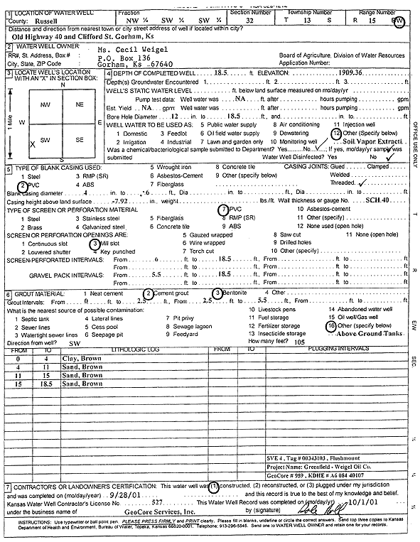
| Owner: Weigel, Ms. Cecil | Status: Constructed | ||
| Location: T13S, R15W, Sec. 32, NW SW SW | County: Russell | ||
| Directions: Old Hwy 40 and Clifford St, Gorham (Tag 00343103) | |||
| Latitude: 38.8736288 | Longitude: -99.0196626 | Datum NAD 27 | |
| Latitude: 38.8736406 | Longitude: -99.0200318 | Datum NAD 83 | |
| Longitude and latitude calculated by Survey from township-range-section-quarter calls. Only good to within the quarter call accuracy. | |||
| View well on interactive map | |||
| General Info | ||
| Well Depth: 18.5 ft. | Elevation: 1909.36 ft. | |
| Static Water Level: ft. | Est. Yield: gpm. | |
| Comp. Date: 28-Sep-2001 | Well Use: Environmental Remediation, Soil Vapor Extraction | |
| DWR Applic. #: | Other ID: SVE 4 | |
| Driller Info | ||
| Driller: GeoCore Services Inc. | License #: 527 | |
| Scanned Form | View scan |
|
Chemical Sample Submitted?:
Water Well disinfected?: | ||
| Casing Info | ||
| Casing Type:
Casing Joints: |
Diam: in. to ft | |
| Casing height above land surface: in
Casing Weight: lbs/ft Wall thickness or gauge no.: | ||
| Screen and Perforation Info | ||
| Screen Type: | Screen Openings: | |
| Screen-perforated intervals | From: ft to ft | |
| Gravel pack intervals | From: ft to ft | |
| Grout Info | ||
| Grout used: | From: to ft | |
| Source of Possible Contamination | ||
| Source: | ||
| Direction from well: | Distance: ft | |
| Lithologic Log
(Log data entered by KGS.) | ||
| From: 0 ft. to 4 ft. | clay, brown | |
| From: 4 ft. to 11 ft. | sand, brown | |
| From: 11 ft. to 15 ft. | sand, brown | |
| From: 15 ft. to 18.5 ft. | sand, brown | |