|
|
|
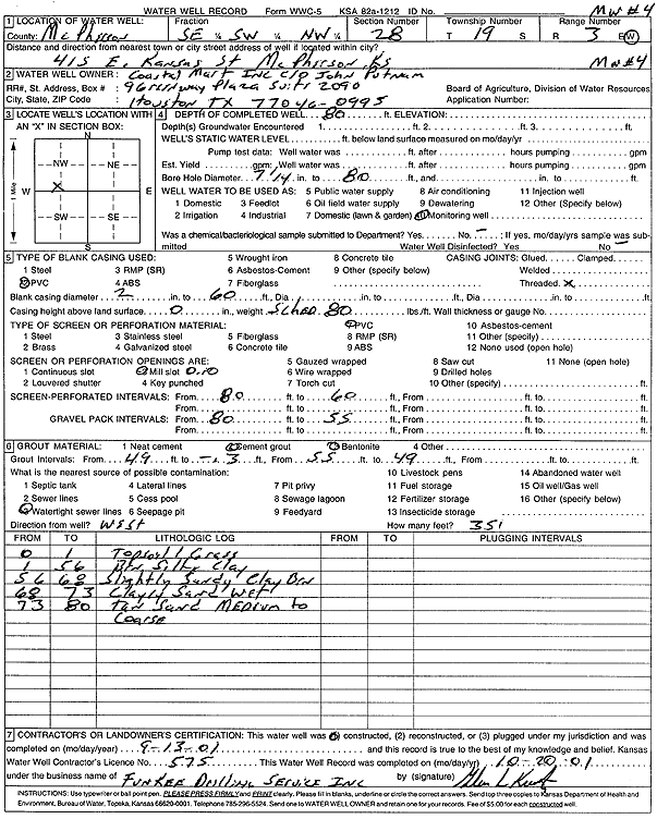
Specific Water Well Detail |
|
|
| Location Info | |||
| Owner: Coastal Mart, Inc. | Status: Constructed | ||
| Location: T19S, R3W, Sec. 28, SE SW NW | County: McPherson | ||
| Directions: 415 E Kansas St, McPherson | |||
| Latitude: 38.3702914 | Longitude: -97.6631342 | Datum NAD 27 | |
| Latitude: 38.3702996 | Longitude: -97.663454 | Datum NAD 83 | |
| Longitude and latitude calculated by Survey from township-range-section-quarter calls. Only good to within the quarter call accuracy. | |||
| View well on interactive map | |||
| General Info | ||
| Well Depth: 80 ft. | Elevation: ft. | |
| Static Water Level: ft. | Est. Yield: gpm. | |
| Comp. Date: 13-Sep-2001 | Well Use: Monitoring well/observation/piezometer | |
| DWR Applic. #: | Other ID: MW 4 | |
| Driller Info | ||
| Driller: Funkee Drilling Service | License #: 575 | |
| Scanned Form | View scan |
|
Chemical Sample Submitted?:
Water Well disinfected?: | ||
| Casing Info | ||
| Casing Type:
Casing Joints: |
Diam: in. to ft | |
| Casing height above land surface: in
Casing Weight: lbs/ft Wall thickness or gauge no.: | ||
| Screen and Perforation Info | ||
| Screen Type: | Screen Openings: | |
| Screen-perforated intervals | From: ft to ft | |
| Gravel pack intervals | From: ft to ft | |
| Grout Info | ||
| Grout used: | From: to ft | |
| Source of Possible Contamination | ||
| Source: | ||
| Direction from well: | Distance: ft | |
| Lithologic Log
(Log data entered by KGS.) | ||
| From: 0 ft. to 1 ft. | grass, top soil | |
| From: 1 ft. to 56 ft. | red silty clay | |
| From: 56 ft. to 68 ft. | slightly sandy clay, brown | |
| From: 68 ft. to 73 ft. | clayey sand, wet | |
| From: 73 ft. to 80 ft. | tan sand, medium to coarse | |