|
|
|
Specific Water Well Detail |
|
|
| Location Info | |||
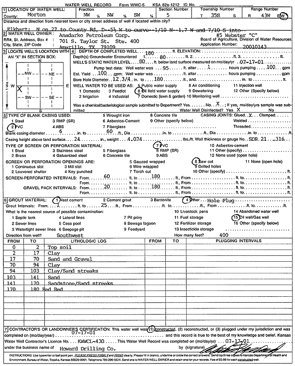
| Owner: Anadarko Petroleum Corp. | Status: Constructed | ||
| Location: T35S, R43W, Sec. 5, NW NW SW | County: Morton | ||
| Directions: from Elkhart: N on 27 to County Rd D, 5.5 W to curve, .1 N, 1.7 W, .7 S into site | |||
| Latitude: 37.0312781 | Longitude: -102.0243692 | Datum NAD 27 | |
| Latitude: 37.0313003 | Longitude: -102.0248183 | Datum NAD 83 | |
| Longitude and latitude calculated by Survey from township-range-section-quarter calls. Only good to within the quarter call accuracy. | |||
| View well on interactive map | |||
| General Info | ||
| Well Depth: 180 ft. | Elevation: ft. | |
| Static Water Level: 80 ft. | Est. Yield: 100 gpm. | |
| Comp. Date: 17-Jul-2001 | Well Use: Oil Field Water Supply | |
| DWR Applic. #: 20010143 | Other ID: Webster C-5 | |
| Links | |
| No Wizard information available. | |
| View info from WIMAS Water Right Data base... | |
| Driller Info | ||
| Driller: Howard Drilling Company AG, LLC | License #: 430 | |
| Scanned Form | View scan |
|
Chemical Sample Submitted?:
Water Well disinfected?: | ||
| Casing Info | ||
| Casing Type:
Casing Joints: |
Diam: in. to ft | |
| Casing height above land surface: in
Casing Weight: lbs/ft Wall thickness or gauge no.: | ||
| Screen and Perforation Info | ||
| Screen Type: | Screen Openings: | |
| Screen-perforated intervals | From: ft to ft | |
| Gravel pack intervals | From: ft to ft | |
| Grout Info | ||
| Grout used: | From: to ft | |
| Source of Possible Contamination | ||
| Source: | ||
| Direction from well: | Distance: ft | |
| Lithologic Log
(Log data entered by KGS.) | ||
| From: 0 ft. to 2 ft. | top soil | |
| From: 2 ft. to 17 ft. | clay | |
| From: 17 ft. to 70 ft. | sand and gravel | |
| From: 70 ft. to 94 ft. | clay | |
| From: 94 ft. to 103 ft. | clay/sand streaks | |
| From: 103 ft. to 141 ft. | sand | |
| From: 141 ft. to 170 ft. | sandstone/sand streaks | |
| From: 170 ft. to 180 ft. | red bed | |