|
|
|
Specific Water Well Detail |
|
|
| Location Info | |||
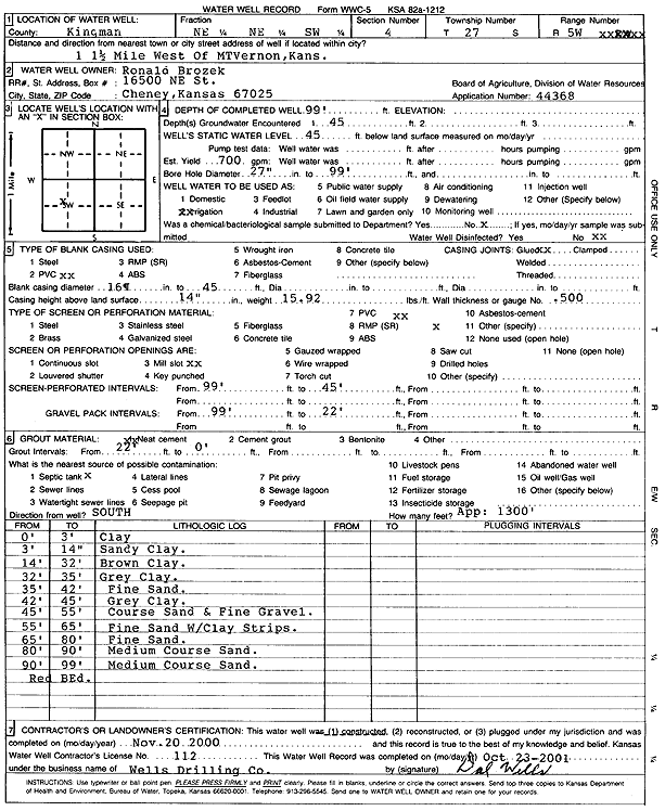
| Owner: Brozek, Ronald | Status: Constructed | ||
| Location: T27S, R5W, Sec. 4, NE NE SW | County: Kingman | ||
| Directions: from Mount Vernon: 1.5 mi W | |||
| Latitude: 37.7251644 | Longitude: -97.8725647 | Datum NAD 27 | |
| Latitude: 37.7251771 | Longitude: -97.8728958 | Datum NAD 83 | |
| Longitude and latitude calculated by Survey from township-range-section-quarter calls. Only good to within the quarter call accuracy. | |||
| View well on interactive map | |||
| General Info | ||
| Well Depth: 99 ft. | Elevation: ft. | |
| Static Water Level: 45 ft. | Est. Yield: 700 gpm. | |
| Comp. Date: 20-Nov-2000 | Well Use: Irrigation | |
| DWR Applic. #: 44368 | Other ID: | |
| Links | |
| No Wizard information available. | |
| View info from WIMAS Water Right Data base... | |
| Driller Info | ||
| Driller: Dal Wells Drilling Co. | License #: 112 | |
| Scanned Form | View scan |
|
Chemical Sample Submitted?:
Water Well disinfected?: | ||
| Casing Info | ||
| Casing Type:
Casing Joints: |
Diam: in. to ft | |
| Casing height above land surface: in
Casing Weight: lbs/ft Wall thickness or gauge no.: | ||
| Screen and Perforation Info | ||
| Screen Type: | Screen Openings: | |
| Screen-perforated intervals | From: ft to ft | |
| Gravel pack intervals | From: ft to ft | |
| Grout Info | ||
| Grout used: | From: to ft | |
| Source of Possible Contamination | ||
| Source: | ||
| Direction from well: | Distance: ft | |
| Lithologic Log
(Log data entered by KGS.) | ||
| From: 0 ft. to 3 ft. | clay | |
| From: 3 ft. to 14 ft. | sandy clay | |
| From: 14 ft. to 32 ft. | brown clay | |
| From: 32 ft. to 35 ft. | gray clay | |
| From: 35 ft. to 42 ft. | fine sand | |
| From: 42 ft. to 45 ft. | gray clay | |
| From: 45 ft. to 55 ft. | coarse sand and fine gravel | |
| From: 55 ft. to 65 ft. | fine sand with clay strips | |
| From: 65 ft. to 80 ft. | fine sand | |
| From: 80 ft. to 90 ft. | medium coarse sand | |
| From: 90 ft. to 99 ft. | medium coarse sand | |
| From: 99 ft. to ft. | red bed | |