|
|
|
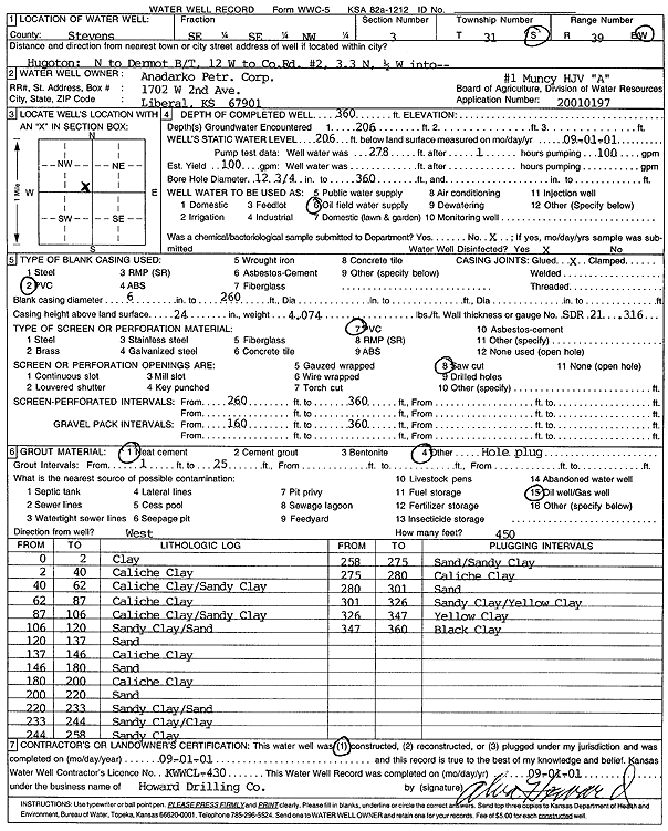
Specific Water Well Detail |
|
|
| Location Info | |||
| Owner: Anadarko Petroleum Corp. | Status: Constructed | ||
| Location: T31S, R39W, Sec. 3, SE SE NW | County: Stevens | ||
| Directions: from Hugoton: N to Dermot B/T, 12 mi W to Cty Rd 2, 3.3 mi N, .5 mi W into site | |||
| Latitude: 37.3821085 | Longitude: -101.5484108 | Datum NAD 27 | |
| Latitude: 37.3821306 | Longitude: -101.5488527 | Datum NAD 83 | |
| Longitude and latitude calculated by Survey from township-range-section-quarter calls. Only good to within the quarter call accuracy. | |||
| View well on interactive map | |||
| General Info | ||
| Well Depth: 360 ft. | Elevation: ft. | |
| Static Water Level: 206 ft. | Est. Yield: 100 gpm. | |
| Comp. Date: 01-Sep-2001 | Well Use: Oil Field Water Supply | |
| DWR Applic. #: 20010197 | Other ID: Muncy HJV A-1 | |
| Links | |
| No Wizard information available. | |
| View info from WIMAS Water Right Data base... | |
| Driller Info | ||
| Driller: Howard Drilling Company AG, LLC | License #: 430 | |
| Scanned Form | View scan |
|
Chemical Sample Submitted?:
Water Well disinfected?: | ||
| Casing Info | ||
| Casing Type:
Casing Joints: |
Diam: in. to ft | |
| Casing height above land surface: in
Casing Weight: lbs/ft Wall thickness or gauge no.: | ||
| Screen and Perforation Info | ||
| Screen Type: | Screen Openings: | |
| Screen-perforated intervals | From: ft to ft | |
| Gravel pack intervals | From: ft to ft | |
| Grout Info | ||
| Grout used: | From: to ft | |
| Source of Possible Contamination | ||
| Source: | ||
| Direction from well: | Distance: ft | |
| Lithologic Log
(Log data entered by KGS.) | ||
| From: 0 ft. to 2 ft. | clay | |
| From: 2 ft. to 40 ft. | caliche clay | |
| From: 40 ft. to 62 ft. | caliche clay/sandy clay | |
| From: 62 ft. to 87 ft. | caliche clay | |
| From: 87 ft. to 106 ft. | caliche clay/sandy clay | |
| From: 106 ft. to 120 ft. | sandy clay/sand | |
| From: 120 ft. to 137 ft. | sand | |
| From: 137 ft. to 146 ft. | caliche clay | |
| From: 146 ft. to 180 ft. | sand | |
| From: 180 ft. to 200 ft. | caliche clay | |
| From: 200 ft. to 220 ft. | sand | |
| From: 220 ft. to 233 ft. | sandy clay/sand | |
| From: 233 ft. to 244 ft. | sandy clay/clay | |
| From: 244 ft. to 258 ft. | sandy clay | |
| From: 258 ft. to 275 ft. | sand/sandy clay | |
| From: 275 ft. to 280 ft. | caliche clay | |
| From: 280 ft. to 301 ft. | sand | |
| From: 301 ft. to 326 ft. | sandy clay/yellow clay | |
| From: 326 ft. to 347 ft. | yellow clay | |
| From: 347 ft. to 360 ft. | black clay | |