|
|
|
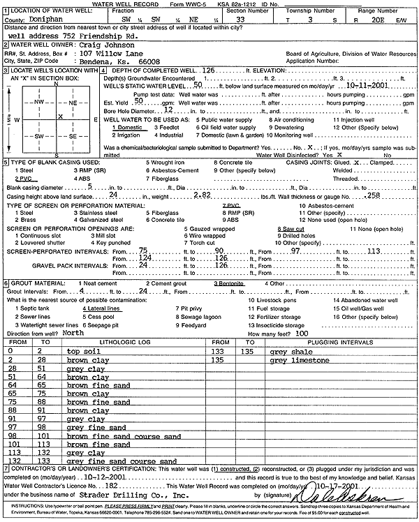
Specific Water Well Detail |
|
|
| Location Info | |||
| Owner: Johnson, Craig | Status: Constructed | ||
| Location: T3S, R20E, Sec. 33, SW SW NE | County: Doniphan | ||
| Directions: 752 Friendship Rd, Bendena | |||
| Latitude: 39.7482824 | Longitude: -95.1796896 | Datum NAD 27 | |
| Latitude: 39.7482798 | Longitude: -95.1799409 | Datum NAD 83 | |
| Longitude and latitude calculated by Survey from township-range-section-quarter calls. Only good to within the quarter call accuracy. | |||
| View well on interactive map | |||
| General Info | ||
| Well Depth: 126 ft. | Elevation: ft. | |
| Static Water Level: 50 ft. | Est. Yield: 50 gpm. | |
| Comp. Date: 12-Oct-2001 | Well Use: Domestic | |
| DWR Applic. #: | Other ID: | |
| Driller Info | ||
| Driller: Strader Drilling Co., Inc. | License #: 182 | |
| Scanned Form | View scan |
|
Chemical Sample Submitted?:
Water Well disinfected?: | ||
| Casing Info | ||
| Casing Type:
Casing Joints: |
Diam: in. to ft | |
| Casing height above land surface: in
Casing Weight: lbs/ft Wall thickness or gauge no.: | ||
| Screen and Perforation Info | ||
| Screen Type: | Screen Openings: | |
| Screen-perforated intervals | From: ft to ft | |
| Gravel pack intervals | From: ft to ft | |
| Grout Info | ||
| Grout used: | From: to ft | |
| Source of Possible Contamination | ||
| Source: | ||
| Direction from well: | Distance: ft | |
| Lithologic Log
(Log data entered by KGS.) | ||
| From: 0 ft. to 2 ft. | Top soil | |
| From: 2 ft. to 28 ft. | Clay, brown | |
| From: 28 ft. to 51 ft. | Clay, gray | |
| From: 51 ft. to 64 ft. | Clay, brown | |
| From: 64 ft. to 65 ft. | Fine sand, brown | |
| From: 65 ft. to 75 ft. | Clay, brown | |
| From: 75 ft. to 88 ft. | Fine sand, brown | |
| From: 88 ft. to 91 ft. | Clay, brown | |
| From: 91 ft. to 97 ft. | Clay, gray | |
| From: 97 ft. to 98 ft. | Fine sand, gray | |
| From: 98 ft. to 101 ft. | Fine sand, coarse sand, brown | |
| From: 101 ft. to 113 ft. | Fine sand, brown | |
| From: 113 ft. to 132 ft. | Clay, gray | |
| From: 132 ft. to 133 ft. | Fine sand, coarse sand, gray | |
| From: 133 ft. to 135 ft. | Shale, gray | |
| From: 135 ft. to ft. | Limestone, gray | |