|
|
|
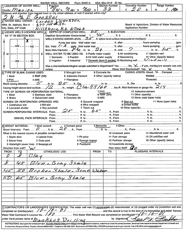
Specific Water Well Detail |
|
|
| Location Info | |||
| Owner: Duerksen, Londell | Status: Constructed | ||
| Location: T20S, R1E, Sec. 33, NW NW NE | County: Marion | ||
| Directions: from Goessel, 2 mi N and 0.5 mi E | |||
| Latitude: 38.2743458 | Longitude: -97.3240779 | Datum NAD 27 | |
| Latitude: 38.2743561 | Longitude: -97.3243888 | Datum NAD 83 | |
| Longitude and latitude calculated by Survey from township-range-section-quarter calls. Only good to within the quarter call accuracy. | |||
| View well on interactive map | |||
| General Info | ||
| Well Depth: 65 ft. | Elevation: ft. | |
| Static Water Level: 35 ft. | Est. Yield: 3 gpm. | |
| Comp. Date: 16-Oct-2001 | Well Use: Domestic, Livestock | |
| DWR Applic. #: | Other ID: | |
| Driller Info | ||
| Driller: Paul H. Backhus Drilling | License #: 180 | |
| Scanned Form | View scan |
|
Chemical Sample Submitted?:
Water Well disinfected?: | ||
| Casing Info | ||
| Casing Type:
Casing Joints: |
Diam: in. to ft | |
| Casing height above land surface: in
Casing Weight: lbs/ft Wall thickness or gauge no.: | ||
| Screen and Perforation Info | ||
| Screen Type: | Screen Openings: | |
| Screen-perforated intervals | From: ft to ft | |
| Gravel pack intervals | From: ft to ft | |
| Grout Info | ||
| Grout used: | From: to ft | |
| Source of Possible Contamination | ||
| Source: | ||
| Direction from well: | Distance: ft | |
| Lithologic Log
(Log data entered by KGS.) | ||
| From: 0 ft. to 8 ft. | clay | |
| From: 8 ft. to 45 ft. | blue and gray shale | |
| From: 45 ft. to 50 ft. | broken shale | |
| From: 50 ft. to 65 ft. | blue and gray shale | |