|
|
|
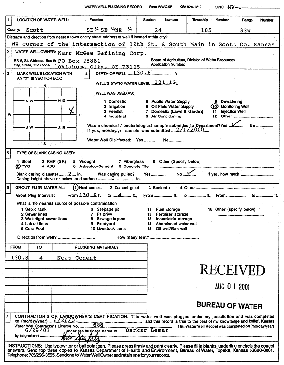
Specific Water Well Detail |
|
|
| Location Info | |||
| Owner: Kerr McGee Refining Corp. | Status: Plugged | ||
| Location: T18S, R33W, Sec. 24, SE SE NE | County: Scott | ||
| Directions: NW corner of 12th St and S Main, Scott City | |||
| Latitude: 38.4760904 | Longitude: -100.9076319 | Datum NAD 27 | |
| Latitude: 38.4761098 | Longitude: -100.9080603 | Datum NAD 83 | |
| Longitude and latitude calculated by Survey from township-range-section-quarter calls. Only good to within the quarter call accuracy. | |||
| View well on interactive map | |||
| General Info | ||
| Well Depth: 130.8 ft. | Elevation: ft. | |
| Static Water Level: 121.1 ft. | Est. Yield: gpm. | |
| Comp. Date: 26-Jun-2001 | Well Use: Monitoring well/observation/piezometer | |
| DWR Applic. #: | Other ID: MW 1 | |
| Driller Info | ||
| Driller: Barker Lemar | License #: 686 | |
| Scanned Form | View scan |
| Casing Info | ||
|
Casing Type:
Diam: in. Casing height above land surface: in | ||
| Grout Info | ||
| Grout used: | From: to ft | |
| Source of Possible Contamination | ||
| Source: | ||
| Direction from well: | Distance: ft | |