|
|
|
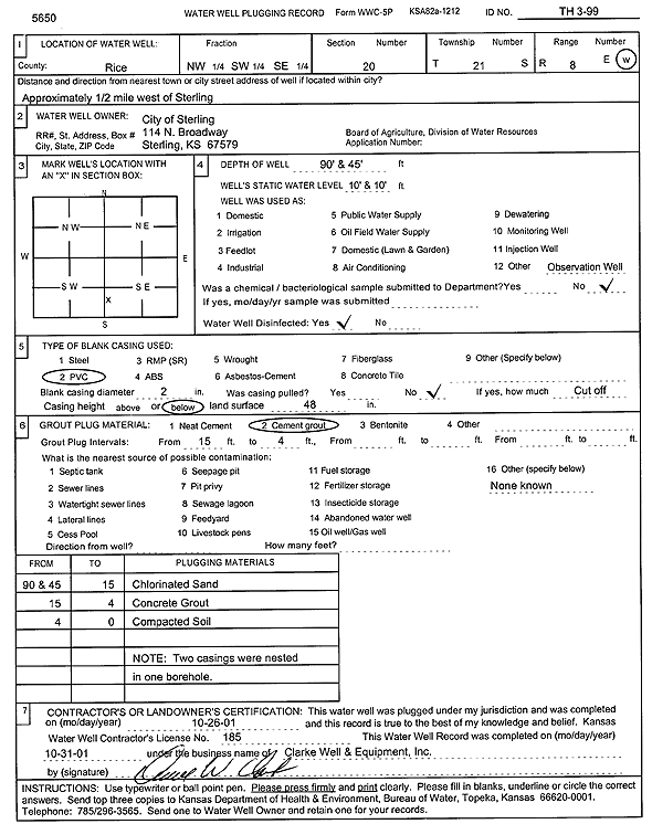
Specific Water Well Detail |
|
|
| Location Info | |||
| Owner: City of Sterling | Status: Plugged | ||
| Location: T21S, R8W, Sec. 20, NW SW SE | County: Rice | ||
| Directions: from Sterling: .5 mi W (id 5650) | |||
| Latitude: 38.2051268 | Longitude: -98.2236248 | Datum NAD 27 | |
| Latitude: 38.2051381 | Longitude: -98.2239648 | Datum NAD 83 | |
| Longitude and latitude calculated by Survey from township-range-section-quarter calls. Only good to within the quarter call accuracy. | |||
| View well on interactive map | |||
| General Info | ||
| Well Depth: 90 ft. | Elevation: ft. | |
| Static Water Level: 10 ft. | Est. Yield: gpm. | |
| Comp. Date: 26-Oct-2001 | Well Use: Monitoring well/observation/piezometer | |
| DWR Applic. #: | Other ID: TH 3-99 | |
| Driller Info | ||
| Driller: Clarke Well and Equipment, Inc. | License #: 185 | |
| Scanned Form | View scan |
| Casing Info | ||
|
Casing Type:
Diam: in. Casing height above land surface: in | ||
| Grout Info | ||
| Grout used: | From: to ft | |
| Source of Possible Contamination | ||
| Source: | ||
| Direction from well: | Distance: ft | |