|
|
|
Specific Water Well Detail |
|
|
| Location Info | |||
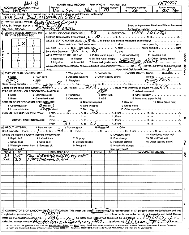
| Owner: Kaneb Pipeline Co. | Status: Constructed | ||
| Location: T26S, R5E, Sec. 10, NE SE NW | County: Butler | ||
| Directions: 1624 Sunset Rd, El Dorado | |||
| Latitude: 37.8055312 | Longitude: -96.872026 | Datum NAD 27 | |
| Latitude: 37.8055489 | Longitude: -96.8723347 | Datum NAD 83 | |
| Longitude and latitude calculated by Survey from township-range-section-quarter calls. Only good to within the quarter call accuracy. | |||
| View well on interactive map | |||
| General Info | ||
| Well Depth: 23 ft. | Elevation: 1294.73 ft. | |
| Static Water Level: 1.53 ft. | Est. Yield: gpm. | |
| Comp. Date: 28-Sep-2001 | Well Use: Monitoring well/observation/piezometer | |
| DWR Applic. #: | Other ID: MW 8 | |
| Driller Info | ||
| Driller: Geotechnical Services, Inc. | License #: 531 | |
| Scanned Form | View scan |
|
Chemical Sample Submitted?:
Water Well disinfected?: | ||
| Casing Info | ||
| Casing Type:
Casing Joints: |
Diam: in. to ft | |
| Casing height above land surface: in
Casing Weight: lbs/ft Wall thickness or gauge no.: | ||
| Screen and Perforation Info | ||
| Screen Type: | Screen Openings: | |
| Screen-perforated intervals | From: ft to ft | |
| Gravel pack intervals | From: ft to ft | |
| Grout Info | ||
| Grout used: | From: to ft | |
| Source of Possible Contamination | ||
| Source: | ||
| Direction from well: | Distance: ft | |
| Lithologic Log
(Log data entered by KGS.) | ||
| From: 0 ft. to 5.5 ft. | clay, dark brown-black-red orange, organic material | |
| From: 5.5 ft. to 23 ft. | limestone, white, hard | |