|
|
|
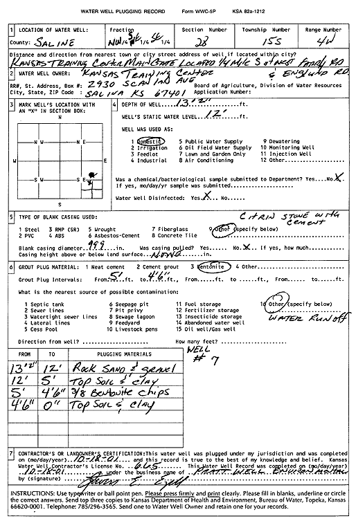
Specific Water Well Detail |
|
|
| Location Info | |||
| Owner: Kansas Training Center | Status: Plugged | ||
| Location: T15S, R4W, Sec. 28, NW SE SE | County: Saline | ||
| Directions: KS Training Center, main gate - from W Farrelly Rd and Englund Rd: .25 mi W | |||
| Latitude: 38.7139213 | Longitude: -97.7649704 | Datum NAD 27 | |
| Latitude: 38.7139269 | Longitude: -97.7652889 | Datum NAD 83 | |
| Longitude and latitude calculated by Survey from township-range-section-quarter calls. Only good to within the quarter call accuracy. | |||
| View well on interactive map | |||
| General Info | ||
| Well Depth: 13.2 ft. | Elevation: ft. | |
| Static Water Level: 12 ft. | Est. Yield: gpm. | |
| Comp. Date: 18-Oct-2001 | Well Use: Domestic | |
| DWR Applic. #: | Other ID: Well 7 | |
| Driller Info | ||
| Driller: Steven E. Ezell, Pratt Well Service, Inc. | License #: 665 | |
| Scanned Form | View scan |
| Casing Info | ||
|
Casing Type:
Diam: in. Casing height above land surface: in | ||
| Grout Info | ||
| Grout used: | From: to ft | |
| Source of Possible Contamination | ||
| Source: | ||
| Direction from well: | Distance: ft | |