|
|
|
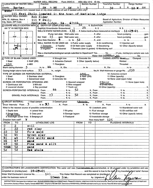
Specific Water Well Detail |
|
|
| Location Info | |||
| Owner: Elder, Ron | Status: Constructed | ||
| Location: T32S, R12W, Sec. 1, SW NE SW | County: Barber | ||
| Directions: 111 W Stolp, Medicine Lodge | |||
| Latitude: 37.2875556 | Longitude: -98.5806833 | Datum NAD 27 | |
| Latitude: 37.2875783 | Longitude: -98.5810445 | Datum NAD 83 | |
| Longitude and latitude calculated by Survey from township-range-section-quarter calls. Only good to within the quarter call accuracy. | |||
| View well on interactive map | |||
| General Info | ||
| Well Depth: 52 ft. | Elevation: ft. | |
| Static Water Level: 13.5 ft. | Est. Yield: 15 gpm. | |
| Comp. Date: 29-Oct-2001 | Well Use: Domestic | |
| DWR Applic. #: | Other ID: | |
| Driller Info | ||
| Driller: Dean L. Lyman, Inc. | License #: 140 | |
| Scanned Form | View scan |
|
Chemical Sample Submitted?:
Water Well disinfected?: | ||
| Casing Info | ||
| Casing Type:
Casing Joints: |
Diam: in. to ft | |
| Casing height above land surface: in
Casing Weight: lbs/ft Wall thickness or gauge no.: | ||
| Screen and Perforation Info | ||
| Screen Type: | Screen Openings: | |
| Screen-perforated intervals | From: ft to ft | |
| Gravel pack intervals | From: ft to ft | |
| Grout Info | ||
| Grout used: | From: to ft | |
| Source of Possible Contamination | ||
| Source: | ||
| Direction from well: | Distance: ft | |
| Lithologic Log
(Log data entered by KGS.) | ||
| From: 0 ft. to 2 ft. | soil | |
| From: 2 ft. to 22 ft. | red clay | |
| From: 22 ft. to 32 ft. | fine sand | |
| From: 32 ft. to 41 ft. | brown clay | |
| From: 41 ft. to 44 ft. | sand | |
| From: 44 ft. to 47 ft. | sand | |
| From: 47 ft. to 50 ft. | fine sand and silt | |
| From: 50 ft. to 52 ft. | sand | |
| From: 52 ft. to ft. | red shale | |