|
|
|
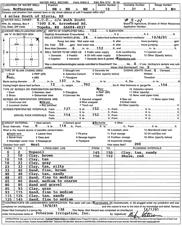
Specific Water Well Detail |
|
|
| Location Info | |||
| Owner: KCC | Status: Constructed | ||
| Location: T21S, R3W, Sec. 10, NE NE NE | County: McPherson | ||
| Directions: from Elyria: 4 mi S | |||
| Latitude: 38.2458421 | Longitude: -97.6298872 | Datum NAD 27 | |
| Latitude: 38.2458511 | Longitude: -97.6302081 | Datum NAD 83 | |
| Longitude and latitude calculated by Survey from township-range-section-quarter calls. Only good to within the quarter call accuracy. | |||
| View well on interactive map | |||
| General Info | ||
| Well Depth: 152 ft. | Elevation: ft. | |
| Static Water Level: 24 ft. | Est. Yield: 50 gpm. | |
| Comp. Date: 08-Oct-2001 | Well Use: Monitoring well/observation/piezometer | |
| DWR Applic. #: | Other ID: MW 3-01 | |
| Driller Info | ||
| Driller: Michael Peterson Irrigation, Inc. | License #: 138 | |
| Scanned Form | View scan |
|
Chemical Sample Submitted?:
Water Well disinfected?: | ||
| Casing Info | ||
| Casing Type:
Casing Joints: |
Diam: in. to ft | |
| Casing height above land surface: in
Casing Weight: lbs/ft Wall thickness or gauge no.: | ||
| Screen and Perforation Info | ||
| Screen Type: | Screen Openings: | |
| Screen-perforated intervals | From: ft to ft | |
| Gravel pack intervals | From: ft to ft | |
| Grout Info | ||
| Grout used: | From: to ft | |
| Source of Possible Contamination | ||
| Source: | ||
| Direction from well: | Distance: ft | |
| Lithologic Log
(Log data entered by KGS.) | ||
| From: 0 ft. to 2 ft. | top soil | |
| From: 2 ft. to 10 ft. | clay, brown | |
| From: 10 ft. to 18 ft. | clay, tan | |
| From: 18 ft. to 23 ft. | clay, gray | |
| From: 23 ft. to 33 ft. | silty clay, tan | |
| From: 33 ft. to 40 ft. | fine sand, brown | |
| From: 40 ft. to 48 ft. | sandy clay, tan | |
| From: 48 ft. to 65 ft. | fine to medium sand | |
| From: 65 ft. to 80 ft. | medium to coarse sand | |
| From: 80 ft. to 85 ft. | sand and gravel | |
| From: 85 ft. to 93 ft. | clay, gray | |
| From: 93 ft. to 115 ft. | fine to medium sand | |
| From: 115 ft. to 125 ft. | sandy clay, tan | |
| From: 125 ft. to 145 ft. | fine to medium sand | |
| From: 145 ft. to 150 ft. | sandy clay, tan | |
| From: 150 ft. to 152 ft. | shale, red | |