|
|
|
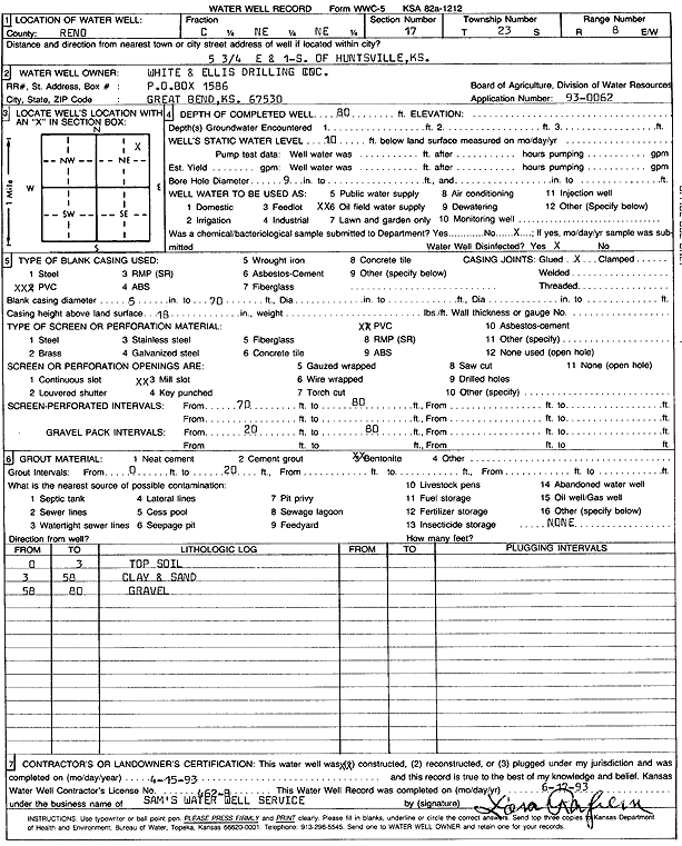
Specific Water Well Detail |
|
|
| Location Info | |||
| Owner: White and Ellis Drilling, Inc. | Status: Constructed | ||
| Location: T23S, R8W, Sec. 17, C NE NE | County: Reno | ||
| Directions: from Huntsville: 5.75 mi E, 1 mi S | |||
| Latitude: 38.0555717 | Longitude: -98.2178945 | Datum NAD 27 | |
| Latitude: 38.0555845 | Longitude: -98.2182354 | Datum NAD 83 | |
| Longitude and latitude calculated by Survey from township-range-section-quarter calls. Only good to within the quarter call accuracy. | |||
| View well on interactive map | |||
| General Info | ||
| Well Depth: 80 ft. | Elevation: ft. | |
| Static Water Level: 10 ft. | Est. Yield: gpm. | |
| Comp. Date: 15-Apr-1993 | Well Use: Oil Field Water Supply | |
| DWR Applic. #: 930062 | Other ID: | |
| Links | |
| No Wizard information available. | |
| View info from WIMAS Water Right Data base... | |
| Driller Info | ||
| Driller: Sam's Water Well Service | License #: 462 | |
| Scanned Form | View scan |
|
Chemical Sample Submitted?:
Water Well disinfected?: | ||
| Casing Info | ||
| Casing Type:
Casing Joints: |
Diam: in. to ft | |
| Casing height above land surface: in
Casing Weight: lbs/ft Wall thickness or gauge no.: | ||
| Screen and Perforation Info | ||
| Screen Type: | Screen Openings: | |
| Screen-perforated intervals | From: ft to ft | |
| Gravel pack intervals | From: ft to ft | |
| Grout Info | ||
| Grout used: | From: to ft | |
| Source of Possible Contamination | ||
| Source: | ||
| Direction from well: | Distance: ft | |
| Lithologic Log
(Log data entered by KGS.) | ||
| From: 0 ft. to 3 ft. | top soil | |
| From: 3 ft. to 58 ft. | clay and sand | |
| From: 58 ft. to 80 ft. | gravel | |