|
|
|
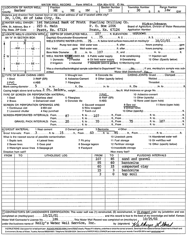
Specific Water Well Detail |
|
|
| Location Info | |||
| Owner: Sterling Drilling Co./1st National Bank of Pratt | Status: Plugged | ||
| Location: T30S, R14W, Sec. 10, NE NE NW | County: Barber | ||
| Directions: from Lake City, 2 mi N, 0.5 mi W, and 4 mi N | |||
| Latitude: 37.4550795 | Longitude: -98.8398805 | Datum NAD 27 | |
| Latitude: 37.4551001 | Longitude: -98.8402541 | Datum NAD 83 | |
| Longitude and latitude calculated by Survey from township-range-section-quarter calls. Only good to within the quarter call accuracy. | |||
| View well on interactive map | |||
| General Info | ||
| Well Depth: 107 ft. | Elevation: ft. | |
| Static Water Level: 75 ft. | Est. Yield: gpm. | |
| Comp. Date: 23-Oct-2001 | Well Use: Oil Field Water Supply | |
| DWR Applic. #: 20010178 | Other ID: Hicks-Johnson | |
| Links | |
| No Wizard information available. | |
| View info from WIMAS Water Right Data base... | |
| Driller Info | ||
| Driller: Kelly's Water Well Service, Inc. | License #: 186 | |
| Scanned Form | View scan |
| Casing Info | ||
|
Casing Type:
Diam: in. Casing height above land surface: in | ||
| Grout Info | ||
| Grout used: | From: to ft | |
| Source of Possible Contamination | ||
| Source: | ||
| Direction from well: | Distance: ft | |