|
|
|
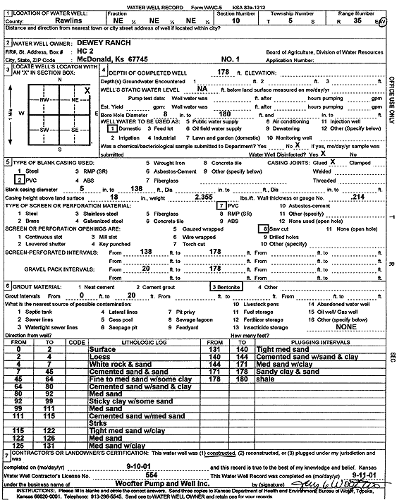
Specific Water Well Detail |
|
|
| Location Info | |||
| Owner: Dewey Ranch | Status: Constructed | ||
| Location: T5S, R35W, Sec. 10, NE NE NE | County: Rawlins | ||
| Directions: | |||
| Latitude: 39.6399676 | Longitude: -101.226707 | Datum NAD 27 | |
| Latitude: 39.6399672 | Longitude: -101.2271443 | Datum NAD 83 | |
| Longitude and latitude calculated by Survey from township-range-section-quarter calls. Only good to within the quarter call accuracy. | |||
| View well on interactive map | |||
| General Info | ||
| Well Depth: 178 ft. | Elevation: ft. | |
| Static Water Level: ft. | Est. Yield: gpm. | |
| Comp. Date: 10-Sep-2001 | Well Use: Domestic | |
| DWR Applic. #: | Other ID: Well 1 | |
| Driller Info | ||
| Driller: Jay C. Woofter Pump & Well, Inc. | License #: 554 | |
| Scanned Form | View scan |
|
Chemical Sample Submitted?:
Water Well disinfected?: | ||
| Casing Info | ||
| Casing Type:
Casing Joints: |
Diam: in. to ft | |
| Casing height above land surface: in
Casing Weight: lbs/ft Wall thickness or gauge no.: | ||
| Screen and Perforation Info | ||
| Screen Type: | Screen Openings: | |
| Screen-perforated intervals | From: ft to ft | |
| Gravel pack intervals | From: ft to ft | |
| Grout Info | ||
| Grout used: | From: to ft | |
| Source of Possible Contamination | ||
| Source: | ||
| Direction from well: | Distance: ft | |
| Lithologic Log
(Log data entered by KGS.) | ||
| From: 0 ft. to 2 ft. | surface | |
| From: 2 ft. to 4 ft. | loess | |
| From: 4 ft. to 7 ft. | white rock and sand | |
| From: 7 ft. to 45 ft. | cemented sand and sand | |
| From: 45 ft. to 64 ft. | fine to medium sand with some clay | |
| From: 64 ft. to 80 ft. | cemented sand with sand and clay | |
| From: 80 ft. to 92 ft. | medium sand | |
| From: 92 ft. to 99 ft. | sticky clay with some sand | |
| From: 99 ft. to 111 ft. | medium sand | |
| From: 111 ft. to 115 ft. | cemented sand with medium sand streaks | |
| From: 115 ft. to 122 ft. | tight medium sand with clay | |
| From: 122 ft. to 125 ft. | medium sand | |
| From: 125 ft. to 131 ft. | medium sand with clay | |
| From: 131 ft. to 140 ft. | tight medium sand | |
| From: 140 ft. to 144 ft. | cemented sand with sand and clay | |
| From: 144 ft. to 171 ft. | medium sand with clay | |
| From: 171 ft. to 178 ft. | sandy clay and sand | |
| From: 178 ft. to 180 ft. | shale | |