|
|
|
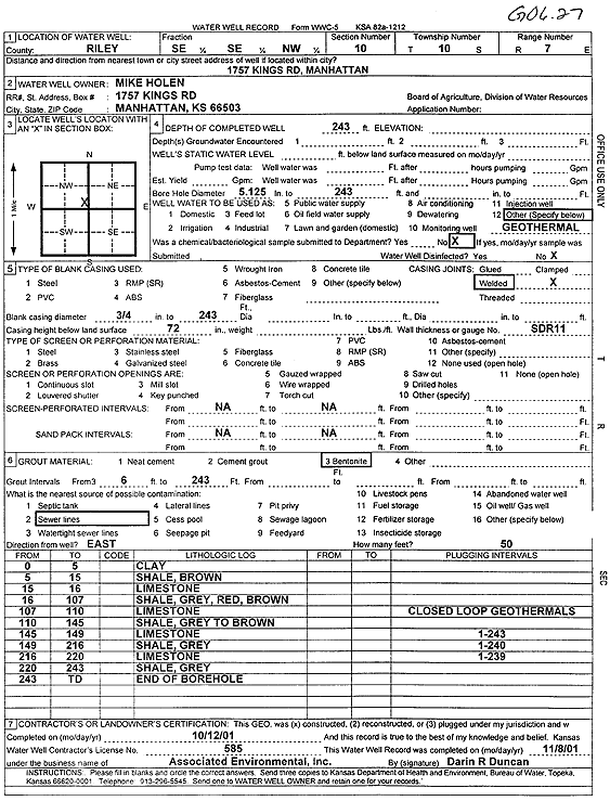
Specific Water Well Detail |
|
|
| Location Info | |||
| Owner: Holen, Mike | Status: Constructed | ||
| Location: T10S, R7E, Sec. 10, SE SE NW | County: Riley | ||
| Directions: 1757 Kings Rd, Manhattan (1 bore at 243', 1 bore at 240', 1 bore at 239') | |||
| Latitude: 39.1972932 | Longitude: -96.6364201 | Datum NAD 27 | |
| Latitude: 39.19729 | Longitude: -96.6367023 | Datum NAD 83 | |
| Longitude and latitude calculated by Survey from township-range-section-quarter calls. Only good to within the quarter call accuracy. | |||
| View well on interactive map | |||
| General Info | ||
| Well Depth: 243 ft. | Elevation: ft. | |
| Static Water Level: ft. | Est. Yield: gpm. | |
| Comp. Date: 12-Oct-2001 | Well Use: Geothermal, Closed Loop, Vertical | |
| DWR Applic. #: | Other ID: GO 6.27 | |
| Driller Info | ||
| Driller: Associated Environmental, Inc. | License #: 585 | |
| Scanned Form | View scan |
|
Chemical Sample Submitted?:
Water Well disinfected?: | ||
| Casing Info | ||
| Casing Type:
Casing Joints: |
Diam: in. to ft | |
| Casing height above land surface: in
Casing Weight: lbs/ft Wall thickness or gauge no.: | ||
| Screen and Perforation Info | ||
| Screen Type: | Screen Openings: | |
| Screen-perforated intervals | From: ft to ft | |
| Gravel pack intervals | From: ft to ft | |
| Grout Info | ||
| Grout used: | From: to ft | |
| Source of Possible Contamination | ||
| Source: | ||
| Direction from well: | Distance: ft | |
| Lithologic Log
(Log data entered by KGS.) | ||
| From: 0 ft. to 5 ft. | clay | |
| From: 5 ft. to 15 ft. | shale, brown | |
| From: 15 ft. to 16 ft. | limestone | |
| From: 16 ft. to 107 ft. | shale, gray, red, brown | |
| From: 107 ft. to 110 ft. | limestone | |
| From: 110 ft. to 145 ft. | shale, gray to brown | |
| From: 145 ft. to 149 ft. | limestone | |
| From: 149 ft. to 216 ft. | shale, gray | |
| From: 216 ft. to 220 ft. | limestone | |
| From: 220 ft. to 243 ft. | shale, gray | |