|
|
|
Specific Water Well Detail |
|
|
| Location Info | |||
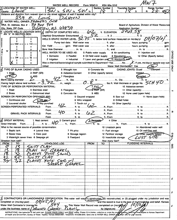
| Owner: Farmers Coop | Status: Constructed | ||
| Location: T18S, R28W, Sec. 18, SW SW SW | County: Lane | ||
| Directions: 239 E Long, Dighton | |||
| Latitude: 38.4829893 | Longitude: -100.4654674 | Datum NAD 27 | |
| Latitude: 38.4830061 | Longitude: -100.4658851 | Datum NAD 83 | |
| Longitude and latitude calculated by Survey from township-range-section-quarter calls. Only good to within the quarter call accuracy. | |||
| View well on interactive map | |||
| General Info | ||
| Well Depth: 62 ft. | Elevation: 2763.58 ft. | |
| Static Water Level: 52.75 ft. | Est. Yield: gpm. | |
| Comp. Date: 05-Sep-2001 | Well Use: Monitoring well/observation/piezometer | |
| DWR Applic. #: | Other ID: MW 7 | |
| Driller Info | ||
| Driller: Coranco Great Plains, Inc. | License #: 594 | |
| Scanned Form | View scan |
|
Chemical Sample Submitted?:
Water Well disinfected?: | ||
| Casing Info | ||
| Casing Type:
Casing Joints: |
Diam: in. to ft | |
| Casing height above land surface: in
Casing Weight: lbs/ft Wall thickness or gauge no.: | ||
| Screen and Perforation Info | ||
| Screen Type: | Screen Openings: | |
| Screen-perforated intervals | From: ft to ft | |
| Gravel pack intervals | From: ft to ft | |
| Grout Info | ||
| Grout used: | From: to ft | |
| Source of Possible Contamination | ||
| Source: | ||
| Direction from well: | Distance: ft | |
| Lithologic Log
(Log data entered by KGS.) | ||
| From: 0 ft. to 13 ft. | Silty clay | |
| From: 13 ft. to 18 ft. | Clay with gravel | |
| From: 18 ft. to 32 ft. | Clayey fine sand | |
| From: 32 ft. to 35 ft. | Silty clay | |
| From: 35 ft. to 62 ft. | Clayey fine sand with sparse gravel | |