|
|
|
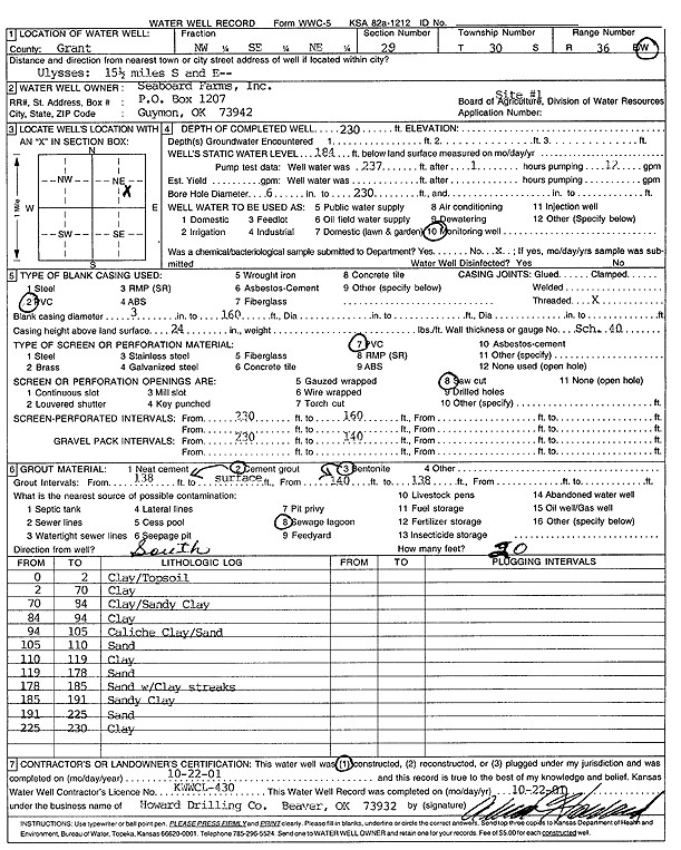
Specific Water Well Detail |
|
|
| Location Info | |||
| Owner: Seaboard Farms | Status: Constructed | ||
| Location: T30S, R36W, Sec. 29, NW SE NE | County: Grant | ||
| Directions: Ulysses: 15.5 mi S, E into site | |||
| Latitude: 37.412421 | Longitude: -101.2740599 | Datum NAD 27 | |
| Latitude: 37.4124444 | Longitude: -101.2745022 | Datum NAD 83 | |
| Longitude and latitude calculated by Survey from township-range-section-quarter calls. Only good to within the quarter call accuracy. | |||
| View well on interactive map | |||
| General Info | ||
| Well Depth: 230 ft. | Elevation: ft. | |
| Static Water Level: 184 ft. | Est. Yield: gpm. | |
| Comp. Date: 22-Oct-2001 | Well Use: Monitoring well/observation/piezometer | |
| DWR Applic. #: | Other ID: Site 1 | |
| Driller Info | ||
| Driller: Howard Drilling Company AG, LLC | License #: 430 | |
| Scanned Form | View scan |
|
Chemical Sample Submitted?:
Water Well disinfected?: | ||
| Casing Info | ||
| Casing Type:
Casing Joints: |
Diam: in. to ft | |
| Casing height above land surface: in
Casing Weight: lbs/ft Wall thickness or gauge no.: | ||
| Screen and Perforation Info | ||
| Screen Type: | Screen Openings: | |
| Screen-perforated intervals | From: ft to ft | |
| Gravel pack intervals | From: ft to ft | |
| Grout Info | ||
| Grout used: | From: to ft | |
| Source of Possible Contamination | ||
| Source: | ||
| Direction from well: | Distance: ft | |
| Lithologic Log
(Log data entered by KGS.) | ||
| From: 0 ft. to 2 ft. | Clay/Topsoil | |
| From: 2 ft. to 70 ft. | Clay | |
| From: 70 ft. to 84 ft. | Clay/Sandy Clay | |
| From: 84 ft. to 94 ft. | Clay | |
| From: 94 ft. to 105 ft. | Caliche Clay/Sand | |
| From: 105 ft. to 110 ft. | Sand | |
| From: 110 ft. to 119 ft. | Clay | |
| From: 119 ft. to 178 ft. | Sand | |
| From: 178 ft. to 185 ft. | Sand with Clay streaks | |
| From: 185 ft. to 191 ft. | Sandy Clay | |
| From: 191 ft. to 225 ft. | Sand | |
| From: 225 ft. to 230 ft. | Clay | |