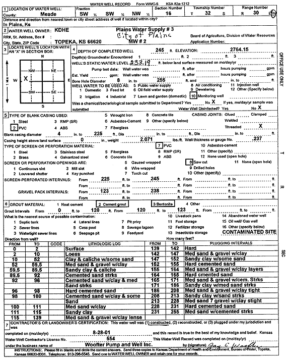
![]() |
![]() |
Specific Water Well Detail |
![]() |
Location Info | |||
Owner: KDHE | Status: Constructed | ||
Location: T32S, R30W, Sec. 16, SW SW NW | County: Meade | ||
Directions: | |||
Latitude: 37.265134 | Longitude: -100.5972211 | Datum NAD 27 | |
Latitude: 37.2651555 | Longitude: -100.5976516 | Datum NAD 83 | |
Longitude and latitude calculated by Survey from township-range-section-quarter calls. Only good to within the quarter call accuracy. | |||
View well on interactive map |
General Info | ||
Well Depth: 245 ft. | Elevation: 2764.15 ft. | |
Static Water Level: 233.1 ft. | Est. Yield: gpm. | |
Comp. Date: 28-Aug-2001 | Well Use: Monitoring well/observation/piezometer | |
DWR Applic. #: | Other ID: MW 2 |
Driller Info | ||
Driller: Jay C. Woofter Pump & Well, Inc. | License #: 554 |
Scanned Form | ||
View form(s) on screen | Download scan(s) | |
The download files contain one or more TIFF images compressed into a ZIP archive. Your browser may be already set up to decompress these files. The TIFFs are 300 dpi archival-quality scans of the WWC5 forms and can be viewed by software like Adobe PhotoShop. |
Chemical Sample Submitted?:
Water Well disinfected?: | ||
Casing Info | ||
Casing Type:
Casing Joints: |
Diam: in. to ft | |
Casing height above land surface: in
Casing Weight: lbs/ft Wall thickness or gauge no.: |
Screen and Perforation Info | ||
Screen Type: | Screen Openings: | |
Screen-perforated intervals | From: ft to ft | |
Gravel pack intervals | From: ft to ft |
Grout Info | ||
Grout used: | From: to ft |
Source of Possible Contamination | ||
Source: | ||
Direction from well: | Distance: ft |
Lithologic Log
(Log data entered by KGS.) | ||
From: 0 ft. to 2 ft. | surface | |
From: 2 ft. to 10 ft. | loess | |
From: 10 ft. to 52 ft. | clay and caliche with some sand | |
From: 52 ft. to 59.5 ft. | medium sand and gravel with clay | |
From: 59.5 ft. to 89.5 ft. | sandy clay and caliche | |
From: 89.5 ft. to 92 ft. | cemented sand streaks | |
From: 92 ft. to 96 ft. | cemented sand with clay and medium sand streaks | |
From: 96 ft. to 98 ft. | hard cemented sand | |
From: 98 ft. to 100 ft. | cemented sand with clay and some sand | |
From: 100 ft. to 111 ft. | medium sand with clay | |
From: 111 ft. to 115 ft. | sandy clay | |
From: 115 ft. to 139 ft. | medium sand and gravel with clay lens | |
From: 139 ft. to 142 ft. | hard | |
From: 142 ft. to 147 ft. | medium sand and gravel with clay | |
From: 147 ft. to 152 ft. | sandy clay with some sand | |
From: 152 ft. to 155 ft. | hard cemented sand | |
From: 155 ft. to 164 ft. | medium sand and gravel with clay layers | |
From: 164 ft. to 165 ft. | hard cemented sand | |
From: 165 ft. to 171 ft. | medium sandy clay with medium sand streaks | |
From: 171 ft. to 186 ft. | sandy clay with medium sand streaks | |
From: 186 ft. to 208 ft. | medium sand and gravel with clay tight | |
From: 208 ft. to 213 ft. | sandy clay with sand streaks | |
From: 213 ft. to 228 ft. | medium sand and gravel with clay streak | |
From: 228 ft. to 231 ft. | hard cemented sand | |
From: 231 ft. to 255 ft. | medium sand with cemented streaks |