|
|
|
Specific Water Well Detail |
|
|
| Location Info | |||
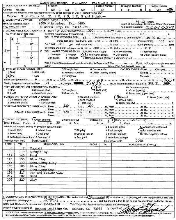
| Owner: Raydon Exploration Co., Inc. | Status: Constructed | ||
| Location: T35S, R28W, Sec. 12, NW NW NW | County: Meade | ||
| Directions: from Meade: S on 23 Hwy to Rd DD, 7 mi E, 2 mi S, 1 mi E, SE into (1-12 Ross) | |||
| Latitude: 37.0233265 | Longitude: -100.3232547 | Datum NAD 27 | |
| Latitude: 37.0233538 | Longitude: -100.3236779 | Datum NAD 83 | |
| Longitude and latitude calculated by Survey from township-range-section-quarter calls. Only good to within the quarter call accuracy. | |||
| View well on interactive map | |||
| General Info | ||
| Well Depth: 300 ft. | Elevation: ft. | |
| Static Water Level: 65 ft. | Est. Yield: gpm. | |
| Comp. Date: 09-Oct-2001 | Well Use: Oil Field Water Supply | |
| DWR Applic. #: 20010249 | Other ID: 1-12 Ross | |
| Driller Info | ||
| Driller: Howard Drilling Company AG, LLC | License #: 430 | |
| Scanned Form | View scan |
|
Chemical Sample Submitted?:
Water Well disinfected?: | ||
| Casing Info | ||
| Casing Type:
Casing Joints: |
Diam: in. to ft | |
| Casing height above land surface: in
Casing Weight: lbs/ft Wall thickness or gauge no.: | ||
| Screen and Perforation Info | ||
| Screen Type: | Screen Openings: | |
| Screen-perforated intervals | From: ft to ft | |
| Gravel pack intervals | From: ft to ft | |
| Grout Info | ||
| Grout used: | From: to ft | |
| Source of Possible Contamination | ||
| Source: | ||
| Direction from well: | Distance: ft | |
| Lithologic Log
(Log data entered by KGS.) | ||
| From: 0 ft. to 2 ft. | top soil | |
| From: 2 ft. to 119 ft. | sandy clay | |
| From: 119 ft. to 145 ft. | sand | |
| From: 145 ft. to 155 ft. | blue clay | |
| From: 155 ft. to 170 ft. | sand and sandy clay | |
| From: 170 ft. to 185 ft. | blue clay | |
| From: 185 ft. to 195 ft. | sand and sandstone | |
| From: 195 ft. to 217 ft. | tan and yellow clay | |
| From: 217 ft. to 302 ft. | sand | |
| From: 302 ft. to 320 ft. | clay | |