|
|
|
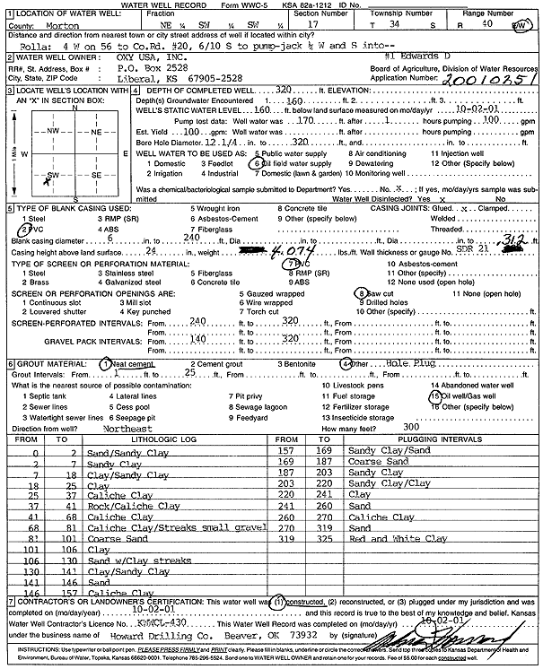
Specific Water Well Detail |
|
|
| Location Info | |||
| Owner: Oxy USA, Inc. | Status: Constructed | ||
| Location: T34S, R40W, Sec. 17, NE SW SW | County: Morton | ||
| Directions: from Rolla: 4 mi W on Hwy 56 to County Rd 20, .6 mi S, to pump-jack, SW into site | |||
| Latitude: 37.0862929 | Longitude: -101.6966737 | Datum NAD 27 | |
| Latitude: 37.0863179 | Longitude: -101.6971136 | Datum NAD 83 | |
| Longitude and latitude calculated by Survey from township-range-section-quarter calls. Only good to within the quarter call accuracy. | |||
| View well on interactive map | |||
| General Info | ||
| Well Depth: 320 ft. | Elevation: ft. | |
| Static Water Level: 160 ft. | Est. Yield: 100 gpm. | |
| Comp. Date: 02-Oct-2001 | Well Use: Oil Field Water Supply | |
| DWR Applic. #: 20010251 | Other ID: Edwards D 1 | |
| Links | |
| No Wizard information available. | |
| View info from WIMAS Water Right Data base... | |
| Driller Info | ||
| Driller: Howard Drilling Company AG, LLC | License #: 430 | |
| Scanned Form | View scan |
|
Chemical Sample Submitted?:
Water Well disinfected?: | ||
| Casing Info | ||
| Casing Type:
Casing Joints: |
Diam: in. to ft | |
| Casing height above land surface: in
Casing Weight: lbs/ft Wall thickness or gauge no.: | ||
| Screen and Perforation Info | ||
| Screen Type: | Screen Openings: | |
| Screen-perforated intervals | From: ft to ft | |
| Gravel pack intervals | From: ft to ft | |
| Grout Info | ||
| Grout used: | From: to ft | |
| Source of Possible Contamination | ||
| Source: | ||
| Direction from well: | Distance: ft | |
| Lithologic Log
(Log data entered by KGS.) | ||
| From: 0 ft. to 2 ft. | sand/sandy clay | |
| From: 2 ft. to 7 ft. | sandy clay | |
| From: 7 ft. to 18 ft. | clay/sandy clay | |
| From: 18 ft. to 25 ft. | clay | |
| From: 25 ft. to 37 ft. | caliche clay | |
| From: 37 ft. to 41 ft. | rock/caliche clay | |
| From: 41 ft. to 68 ft. | caliche clay | |
| From: 68 ft. to 81 ft. | caliche clay/streaks small gravel | |
| From: 81 ft. to 101 ft. | coarse sand | |
| From: 101 ft. to 106 ft. | clay | |
| From: 106 ft. to 130 ft. | sand w/clay streaks | |
| From: 130 ft. to 141 ft. | clay/sandy clay | |
| From: 141 ft. to 146 ft. | sand | |
| From: 146 ft. to 157 ft. | caliche clay | |
| From: 157 ft. to 169 ft. | sandy clay/sand | |
| From: 169 ft. to 187 ft. | coarse sand | |
| From: 187 ft. to 203 ft. | sandy clay | |
| From: 203 ft. to 220 ft. | sandy clay/sand | |
| From: 220 ft. to 241 ft. | clay | |
| From: 241 ft. to 260 ft. | sand | |
| From: 260 ft. to 270 ft. | caliche clay | |
| From: 270 ft. to 319 ft. | sand | |
| From: 319 ft. to 325 ft. | red and white clay | |