|
|
|
Specific Water Well Detail |
|
|
| Location Info | |||
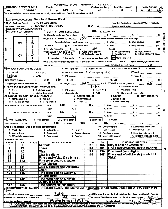
| Owner: Goodland Power Plant | Status: Constructed | ||
| Location: T8S, R39W, Sec. 20, SE NW SW | County: Sherman | ||
| Directions: | |||
| Latitude: 39.3412354 | Longitude: -101.7034314 | Datum NAD 27 | |
| Latitude: 39.3412353 | Longitude: -101.7038812 | Datum NAD 83 | |
| Longitude and latitude calculated by Survey from township-range-section-quarter calls. Only good to within the quarter call accuracy. | |||
| View well on interactive map | |||
| General Info | ||
| Well Depth: 200 ft. | Elevation: ft. | |
| Static Water Level: 189 ft. | Est. Yield: gpm. | |
| Comp. Date: 26-Jul-2001 | Well Use: Monitoring well/observation/piezometer | |
| DWR Applic. #: | Other ID: SVE 4 | |
| Driller Info | ||
| Driller: Jay C. Woofter Pump & Well, Inc. | License #: 554 | |
| Scanned Form | View scan |
|
Chemical Sample Submitted?:
Water Well disinfected?: | ||
| Casing Info | ||
| Casing Type:
Casing Joints: |
Diam: in. to ft | |
| Casing height above land surface: in
Casing Weight: lbs/ft Wall thickness or gauge no.: | ||
| Screen and Perforation Info | ||
| Screen Type: | Screen Openings: | |
| Screen-perforated intervals | From: ft to ft | |
| Gravel pack intervals | From: ft to ft | |
| Grout Info | ||
| Grout used: | From: to ft | |
| Source of Possible Contamination | ||
| Source: | ||
| Direction from well: | Distance: ft | |
| Lithologic Log
(Log data entered by KGS.) | ||
| From: 0 ft. to 1 ft. | Asphalt | |
| From: 1 ft. to 12 ft. | Loess | |
| From: 12 ft. to 42 ft. | Clay | |
| From: 42 ft. to 53 ft. | Clay and caliche | |
| From: 53 ft. to 62 ft. | Fine sand with clay and caliche streak | |
| From: 62 ft. to 112 ft. | Fine to medium sand and gravel with caliche streak | |
| From: 112 ft. to 121 ft. | Clay and caliche with gravel streaks | |
| From: 121 ft. to 123 ft. | Chert | |
| From: 123 ft. to 135 ft. | Fine to medium sand with clay and caliche streaks | |
| From: 135 ft. to 142 ft. | Fine to medium sand and gravel with clay and caliche | |
| From: 142 ft. to 155 ft. | Fine sand with caliche streaks | |
| From: 155 ft. to 164 ft. | Clay and caliche with sand streak | |
| From: 164 ft. to 181 ft. | Fine sand with caliche streak, semi-tight | |
| From: 181 ft. to 194 ft. | Fine sand, semi-tight | |
| From: 194 ft. to 207 ft. | Fine sand with caliche streaks (semi-tight streaks) | |