|
|
|
Specific Water Well Detail |
|
|
| Location Info | |||
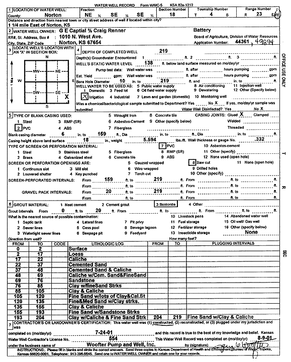
| Owner: Renner, Craig | Status: Constructed | ||
| Location: T4S, R23W, Sec. 18, NE SE SE | County: Norton | ||
| Directions: from Norton: 1.25 mi E | |||
| Latitude: 39.7000199 | Longitude: -99.9470821 | Datum NAD 27 | |
| Latitude: 39.7000249 | Longitude: -99.9474848 | Datum NAD 83 | |
| Longitude and latitude calculated by Survey from township-range-section-quarter calls. Only good to within the quarter call accuracy. | |||
| View well on interactive map | |||
| General Info | ||
| Well Depth: 219 ft. | Elevation: ft. | |
| Static Water Level: 138 ft. | Est. Yield: gpm. | |
| Comp. Date: 24-Jul-2001 | Well Use: Irrigation | |
| DWR Applic. #: 44361 and 43984 | Other ID: | |
| Links | |
| No Wizard information available. | |
| View info from WIMAS Water Right Data base... | |
| Driller Info | ||
| Driller: Jay C. Woofter Pump & Well, Inc. | License #: 554 | |
| Scanned Form | View scan |
|
Chemical Sample Submitted?:
Water Well disinfected?: | ||
| Casing Info | ||
| Casing Type:
Casing Joints: |
Diam: in. to ft | |
| Casing height above land surface: in
Casing Weight: lbs/ft Wall thickness or gauge no.: | ||
| Screen and Perforation Info | ||
| Screen Type: | Screen Openings: | |
| Screen-perforated intervals | From: ft to ft | |
| Gravel pack intervals | From: ft to ft | |
| Grout Info | ||
| Grout used: | From: to ft | |
| Source of Possible Contamination | ||
| Source: | ||
| Direction from well: | Distance: ft | |
| Lithologic Log
(Log data entered by KGS.) | ||
| From: 0 ft. to 2 ft. | surface | |
| From: 2 ft. to 17 ft. | loess | |
| From: 17 ft. to 22 ft. | caliche | |
| From: 22 ft. to 37 ft. | cemented sand | |
| From: 37 ft. to 48 ft. | cemented sand and caliche | |
| From: 48 ft. to 69 ft. | caliche with cemented sand and fine sand | |
| From: 69 ft. to 76 ft. | sandstone | |
| From: 76 ft. to 85 ft. | clay with fine sand streaks | |
| From: 85 ft. to 105 ft. | clay and caliche | |
| From: 105 ft. to 120 ft. | fine sand with lots of clay and caliche streaks | |
| From: 120 ft. to 135 ft. | fine and medium sand with clay streaks | |
| From: 135 ft. to 155 ft. | clay and caliche | |
| From: 155 ft. to 193 ft. | fine sand with sandstone streaks | |
| From: 193 ft. to 204 ft. | clay with caliche and fine sand streak | |
| From: 204 ft. to 219 ft. | fine sand with clay and caliche | |