|
|
|
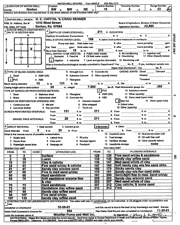
Specific Water Well Detail |
|
|
| Location Info | |||
| Owner: Renner, Craig | Status: Constructed | ||
| Location: T4S, R23W, Sec. 19, SW SW NE | County: Norton | ||
| Directions: | |||
| Latitude: 39.6909918 | Longitude: -99.9540459 | Datum NAD 27 | |
| Latitude: 39.6909968 | Longitude: -99.9544489 | Datum NAD 83 | |
| Longitude and latitude calculated by Survey from township-range-section-quarter calls. Only good to within the quarter call accuracy. | |||
| View well on interactive map | |||
| General Info | ||
| Well Depth: 211 ft. | Elevation: ft. | |
| Static Water Level: 106 ft. | Est. Yield: gpm. | |
| Comp. Date: 09-Oct-2001 | Well Use: Irrigation | |
| DWR Applic. #: 43895 | Other ID: | |
| Links | |
| No Wizard information available. | |
| View info from WIMAS Water Right Data base... | |
| Driller Info | ||
| Driller: Jay C. Woofter Pump & Well, Inc. | License #: 554 | |
| Scanned Form | View scan |
|
Chemical Sample Submitted?:
Water Well disinfected?: | ||
| Casing Info | ||
| Casing Type:
Casing Joints: |
Diam: in. to ft | |
| Casing height above land surface: in
Casing Weight: lbs/ft Wall thickness or gauge no.: | ||
| Screen and Perforation Info | ||
| Screen Type: | Screen Openings: | |
| Screen-perforated intervals | From: ft to ft | |
| Gravel pack intervals | From: ft to ft | |
| Grout Info | ||
| Grout used: | From: to ft | |
| Source of Possible Contamination | ||
| Source: | ||
| Direction from well: | Distance: ft | |
| Lithologic Log
(Log data entered by KGS.) | ||
| From: 0 ft. to 2 ft. | surface | |
| From: 2 ft. to 15 ft. | loess | |
| From: 15 ft. to 33 ft. | clay and caliche | |
| From: 33 ft. to 41 ft. | fine sand with clay and caliche | |
| From: 41 ft. to 47 ft. | sandy clay with some sand | |
| From: 47 ft. to 60 ft. | fine to medium sand with clay | |
| From: 60 ft. to 65 ft. | hard sandstone | |
| From: 65 ft. to 70 ft. | soft sandstone with some fine and clay | |
| From: 70 ft. to 73 ft. | hard sandstone | |
| From: 73 ft. to 90 ft. | sandstone clay with fine sand | |
| From: 90 ft. to 98 ft. | sandy clay with fine sand | |
| From: 98 ft. to 107 ft. | fine sand with clay | |
| From: 107 ft. to 120 ft. | sandy clay with fine sand | |
| From: 120 ft. to 130 ft. | fine sand with clay and sandstone | |
| From: 130 ft. to 135 ft. | sandy clay with fine sand | |
| From: 135 ft. to 147 ft. | medium sand with lots of clay | |
| From: 147 ft. to 160 ft. | soft sandy clay with a few sand streaks | |
| From: 160 ft. to 170 ft. | sticky sandy clay | |
| From: 170 ft. to 181 ft. | sandy clay with a few sand streaks | |
| From: 181 ft. to 200 ft. | semi-tight fine to medium sand with clay | |
| From: 200 ft. to 203 ft. | sandy clay with some sand | |
| From: 203 ft. to 207 ft. | medium sand with lots of clay | |
| From: 207 ft. to 212 ft. | clay caliche and some sand | |
| From: 212 ft. to 213 ft. | flint | |