|
|
|
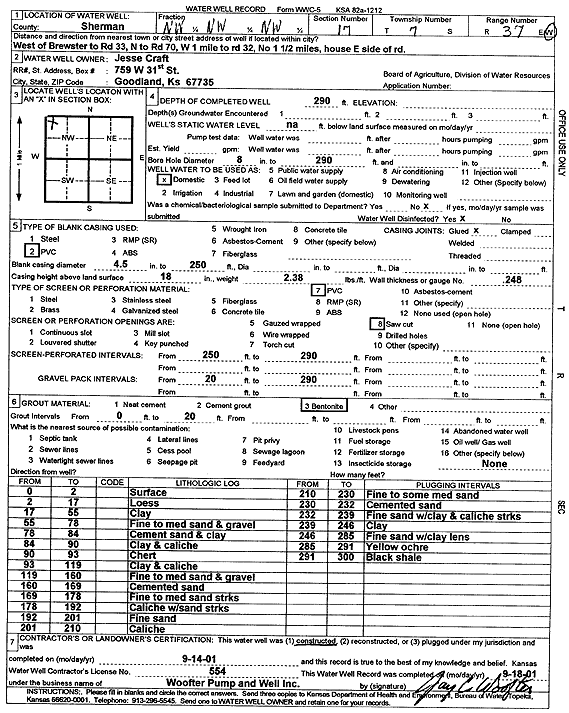
Specific Water Well Detail |
|
|
| Location Info | |||
| Owner: Craft, Jesse | Status: Constructed | ||
| Location: T7S, R37W, Sec. 17, NW NW NW | County: Sherman | ||
| Directions: W of Brewster to Rd 33, N to Rd 70, 1 mi W to Rd 32, 1.5 mi N, E side of rd | |||
| Latitude: 39.4523513 | Longitude: -101.4825799 | Datum NAD 27 | |
| Latitude: 39.4523511 | Longitude: -101.4830234 | Datum NAD 83 | |
| Longitude and latitude calculated by Survey from township-range-section-quarter calls. Only good to within the quarter call accuracy. | |||
| View well on interactive map | |||
| General Info | ||
| Well Depth: 290 ft. | Elevation: ft. | |
| Static Water Level: ft. | Est. Yield: gpm. | |
| Comp. Date: 14-Sep-2001 | Well Use: Domestic | |
| DWR Applic. #: | Other ID: | |
| Driller Info | ||
| Driller: Jay C. Woofter Pump & Well, Inc. | License #: 554 | |
| Scanned Form | View scan |
|
Chemical Sample Submitted?:
Water Well disinfected?: | ||
| Casing Info | ||
| Casing Type:
Casing Joints: |
Diam: in. to ft | |
| Casing height above land surface: in
Casing Weight: lbs/ft Wall thickness or gauge no.: | ||
| Screen and Perforation Info | ||
| Screen Type: | Screen Openings: | |
| Screen-perforated intervals | From: ft to ft | |
| Gravel pack intervals | From: ft to ft | |
| Grout Info | ||
| Grout used: | From: to ft | |
| Source of Possible Contamination | ||
| Source: | ||
| Direction from well: | Distance: ft | |
| Lithologic Log
(Log data entered by KGS.) | ||
| From: 0 ft. to 2 ft. | Surface | |
| From: 2 ft. to 17 ft. | Loess | |
| From: 17 ft. to 55 ft. | Clay | |
| From: 55 ft. to 78 ft. | Fine to medium sand and gravel | |
| From: 78 ft. to 84 ft. | Cement sand and clay | |
| From: 84 ft. to 90 ft. | Clay and caliche | |
| From: 90 ft. to 93 ft. | Chert | |
| From: 93 ft. to 119 ft. | Clay and caliche | |
| From: 119 ft. to 160 ft. | Fine to medium sand and gravel | |
| From: 160 ft. to 169 ft. | Cemented sand | |
| From: 169 ft. to 178 ft. | Fine to medium sand streaks | |
| From: 178 ft. to 192 ft. | Caliche with sand streaks | |
| From: 192 ft. to 201 ft. | Fine sand | |
| From: 201 ft. to 210 ft. | Caliche | |
| From: 210 ft. to 230 ft. | Fine to some medium sand | |
| From: 230 ft. to 232 ft. | Cemented sand | |
| From: 232 ft. to 239 ft. | Fine sand with clay and caliche streaks | |
| From: 239 ft. to 246 ft. | Clay | |
| From: 246 ft. to 285 ft. | Fine sand with clay lens | |
| From: 285 ft. to 291 ft. | Yellow ochre | |
| From: 291 ft. to 300 ft. | Black shale | |